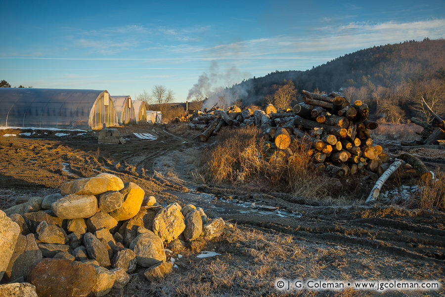
In the rural valley of Nepaug beneath the looming silhouette of Yellow Mountain, farmland is daubed with molten light upon awakening to another January morning. A dirt road creased with frozen ruts weaves amidst piled fieldstones, timbers and greenhouses before vanishing into the farm’s interior.
Although many of Connecticut’s towns have existed for centuries, their configurations have changed dramatically over time. For example, in the 1720s, New Hartford’s pioneering farmers from the Connecticut Colony settled at Town Hill just north of Yellow Mountain (which would’ve been on the far side of the hill as it’s seen in this piece) and thought of their village as the “town center” for next 100 years.
By the 1820s, though, the village of Nepaug emerged as the new town center when its productive streamside mills became the focal point of the community. But even Nepaug would eventually pass the torch when, in the 1870s, New Hartford’s very first Town Hall was built in the district of North Village. North Village had simply outgrown Nepaug during the intervening five decades and, to this very day, it still claims the unofficial designation of town center.
Purchase a Fine Art Print or Inquire About Licensing
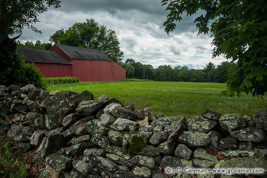
“Yankee Farmlands № 31” is the latest installment in an on-going project of mine in which I celebrate the agricultural heritage of New England through the scenic farmlands of Connecticut. This time around, we find ourselves in the small town of Bolton, peering at a barn and forest-bound meadow over the lichen-encrusted rocks of an iconic fieldstone wall.
Most of New England’s fieldstone walls were built 150 to 200 years ago during an era in which an ever-growing population was feverishly clearing new farmland. Exhausting labor went into constructing these walls as untold tons of stone were plucked from the upper layers of soil, hauled off to the outskirts of the pasture or field and loosely stacked by hand.
These relict stone walls are celebrated for their rustic aesthetic these days, but we might be surprised to discover that they were considered rather mundane at the time of their construction. For the Yankee farmers that built them, fieldstone walls merely represented a practical way to dispose of agricultural refuse. It wasn’t until the 20th-century, when much of New England’s age-old agrarian ways had faded, that rustic stone walls became romantic relics of a simpler, unhurried era in the region’s history.
Purchase a Fine Art Print or Inquire About Licensing
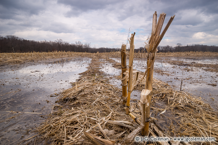
My latest addition to the Yankee Farmlands collection brings us to the town of Bloomfield in Northern Connecticut, where the broken stalks from last year’s corn crop stand in a field which has nearly flooded as warm spells melt away the thick snow pack.
“Mud Season” is the not-too-affectionate term for this time of year in New England. It’s that month-long stretch beginning in late March when the snows are melting away even though the soil below the surface of the ground remains frozen. Meltwater can’t drain through the icy underlayer, so it becomes trapped at the surface and produces a thick slurry of mud.
This was a major source of difficulty in the old days before most of Connecticut’s roads were paved. Horses, wagon wheels and even early cars would get swallowed up in the deep, rutted mud of dirt roads. The resulting mess perennially had a significant impact upon travel in the early springtime. Even still, we here in Southern New England have always had it easier than our neighbors further north. Mud season is far worse in Northern New England, where lower temperatures can freeze the ground much more deeply and springtime mud can hang around well into June!
On a different note, the particular swath of cropland shown here in “Yankee Farmlands № 26” may look like a rather ordinary corn field. But you won’t find any barns or a family farmhouse on this property, because the land is actually owned by the State of Connecticut. This stretch of flatland is a large, designated flood control area nestled amidst the mostly suburban landscape of Bloomfield. Although full-blown floods don’t occur here very often, setting aside this low-lying, poorly-drained area helps protect against unwise development and comes with accompanying benefit of preserving open space. Although I suppose that the state government might grow its own corn here for one reason or another, it seems much more likely that the land is leased to a local farmer who lives off-site and works it as remote field in addition to his or her other land.
Purchase a Fine Art Print or Inquire About Licensing
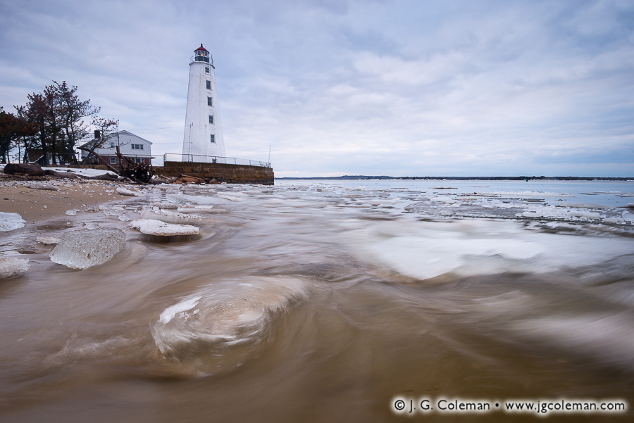
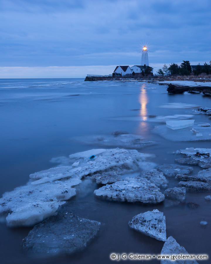
In my new piece “Lynde Point Seascape” (above), the Lynde Point Lighthouse stands sentinel on Long Island Sound at the mouth of the Connecticut River, its column of neatly stacked windows peering towards the sea from a 65-foot brownstone tower. Foreboding clouds loom overhead, while large slabs of wave-thrown ice batter the nearby seashore.
This is just one of my newly-released works featuring the stately Lynde Point Lighthouse in the context of a frigid New England winter. Built in 1838 to replace an older, dilapidated wooden tower, the present beacon at Lynde Point has remained an active aid to maritime navigation for more than a century and half, even as the land surrounding it transitioned from farms and pastures to lightly-wooded suburbs and sizable beachfront cottages.
But just as captivating as the lighthouse during my visit were the chunks of ice drifting on the waves and settling upon the seashore. From jewel-like bits to massive slabs more than 10 feet across, these bergs drifted down the Connecticut River from the state’s interior, only to quickly wash up on the seashores at either side of the river’s mouth.
Days tossing about in the ocean water left some of the ice slabs beautifully polished, their burrs and edges having melted away to reveal a smooth, glassy finish which glistened even in the faint light filtering down through the heavy morning clouds.
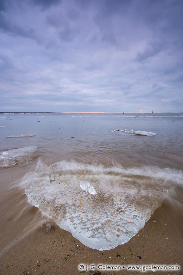
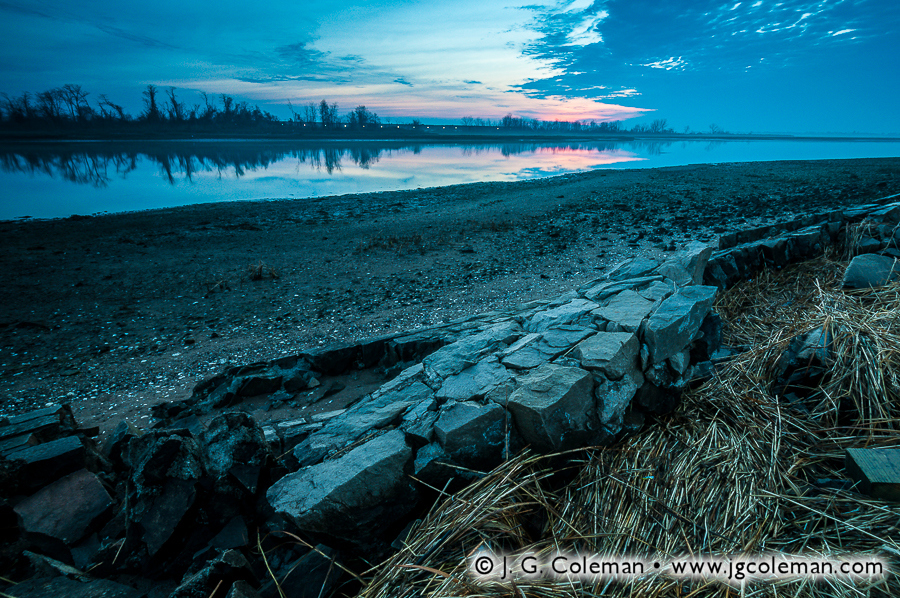
As you can see in my panoramic piece, “Saybrook Vista”, the conditions on this particular morning didn’t exactly offer stunning sunrise colors or dramatic side-lighting. Instead, I was offered some moody, exquisitely-textured cloud cover and only the faint, cool-toned light that was able to filter through. Sure… it’s not the sort of glorious morning that makes you want to lay out a beach towel and stay the afternoon. Then again, would we really expect that sort of idyllic day in late Winter? This is true New England in all of its elemental glory; these are the somber, overcast skies and cold, wind-swept beaches that were part of everyday life for Connecticut mariners of old.
Purchase a Fine Art Print or Inquire About Licensing
Springtime in the American Northeast was described perfectly by Pennsylvania-born author Henry van Dyke in 1899:
“The first day of spring is one thing, and the first spring day is another. The difference between them is sometimes as great as a month.”
Judging by the stillness in the cold air and the snowpack lingering upon the barnyard of the Glastonbury farm in my new piece, “Yankee Farmlands № 25” (above), it would be tough to tell that a season of renewed warmth is upon us. Then again, fields that were covered a yard-deep in snow just a month ago have since thinned out to less than a foot and we’ve had some forgiving temperatures lately.
This much-awaited break in the winter weather is already presenting some fresh new shooting opportunities. Recent warm spells have melted substantial amounts of snow, causing brooks and rivers all over the state to swell. Waterfalls which have been snow-caked and encrusted with ice since January are finally awakening from their seasonal slumber. The woodlands and farmlands alike are still fairly dormant this early in the year, but as snow vanishes from road shoulders and trailhead parking lots, I’ve been delighted to find that I’ve finally got a place to park my truck again!
I’ve eased my cabin fever over these past couple months by putting together a new list of exciting shooting locations in Southern New England; I’m more than eager to get back out into a lively green landscape! So here’s to another long winter being behind us… and another glorious spring ahead!
Purchase a Fine Art Print or Inquire About Licensing
Be sure to check out my Yankee Farmlands collection, the fruit of an on-going project which celebrates the agricultural heritage of the American Northeast through the breath-taking farmlands of Connecticut.
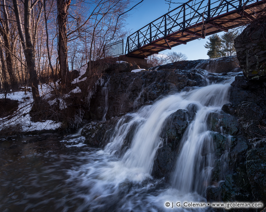
In my new piece, “Heart of the Old Mill”, Mill Pond Falls slips over a shadow-cloaked ledge, its frigid cascades churning to whitewater as it skips over time-worn stone. Above the precipice of the falls, dawn casts warm, sharp light upon a footbridge and snowy woodlands nearby.
Nestled within the center of Newington, Mill Pond Falls is certainly one of Connecticut’s lesser waterfalls at perhaps just 12 to 15 feet in height. Still, the town’s claim that it’s the “smallest natural waterfall in the United States” is no less perplexing.
But while Mill Pond Falls may measure a bit short, it is arguably more beloved than most waterfalls that are several times larger. Each year it is the centerpiece of the “Newington Waterfall Festival” and its cascades are even featured prominently on the town seal! Why so much fanfare over such a diminutive waterfall? During the earliest era of its settlement between the late 1600s and mid-1700s, Newington’s fledging economy was wholly dependent upon these falls to power a local sawmill. So if not for this tiny waterfall, its safe to say that the old colonial village of Newington may have vanished from the map centuries ago.
Purchase a Fine Art Print or Inquire About Licensing
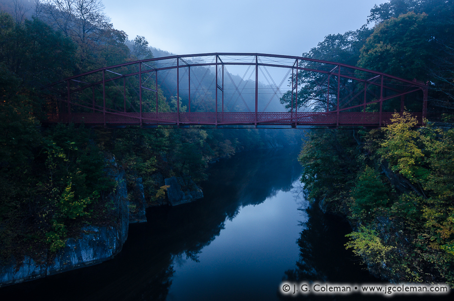
During early autumn last year, I had the great pleasure of arriving at Lovers Leap State Park in New Milford, Connecticut on a warm, misty morning well before dawn. My newly-released piece, “Iron Ghost on the Housatonic”, was certainly my favorite from that dream-like riverscape along the Housatonic River.
The Lovers Leap Bridge, which is silhouetted in the faint twilight over the river gorge, has faithfully spanned the Housatonic since its construction back in 1895. Iron bridges such as these hit the market in the late 1800s and they were oftentimes the “high tech” replacements for older wooden covered bridges. Both bridge designs are rather antiquated these days, even if they were celebrated in their respective eras as marvels of engineering.
The 160-acre Lovers Leap State Park certainly drew its name from the bridge… and the bridge, in turn, drew its name from an old legend which suggests that a Native American girl named Lillinonah, overcome with distraught over a lost lover, leapt to her death here in the Housatonic River. One version of the tale suggests that the heart-broken lover jumped from a 1200-foot mountainous promontory in the heart of the park. But an alternate rendition holds that she threw herself from the precipice of the gorge where one of the abutments for the Lovers Leap Bridge would later be constructed.
Before I wrap up this post, though, I wanted to satiate the curiosity of the rare individual out there who will look at the mirror-smooth waters of the Housatonic River in my photograph (at top) and wonder,” How in the world could somebody perish by jumping into such a tame river?”
Fair enough… the Housatonic River doesn’t exactly look dangerous, does it? But to make sense of the story, we must consider the context of the tale. We know for certain that Lillinonah’s father, Chief Waramaug, died an old man around 1735. So, although we don’t know when exactly the Chief fathered Lillinonah, it’s probable that her tragic end took place somewhere between the 1690s and 1730s. Back then, the Housatonic River still ran wild through New Milford and surrounding lands in deep, precipitous gorges, churning with whitewater as it weaved down through the highlands. Snow melts and heavy rains could produce impressive and deadly displays as the river furiously crashed through its woodland gorges and threatened to flood.
It wasn’t until 1955 that a dam was constructed several miles downstream, impounding the Housatonic River all the way back up into New Milford. Suffice it to say, the placid stretch of river that you can see beneath the Lovers Leap Iron Bridge in my piece, “Iron Ghost on the Housatonic”, would’ve been raucous, swift-flowing rapids in the early days when Lillinonah took her fateful plunge.
Purchase a Fine Art Print or Inquire About Licensing
“It is said that time is unrelated to everything else. It goes on and on, unnoticing of our actions, our falls, our triumphs. Who’s to care then, if time does not remember us? It flies by, fleeting, inattentive and disinterested in any occupants of this earth. What are we, then, if time thinks so little of everyone it passes?”
—Alexia Purdy, “Disarming”
Abandoned places possess a unique allure for those who are receptive to the stories that resonate in the hollows of their vacant buildings and crumbling foundations. Few places in Connecticut so strongly embodied the “post-apocalypse” aesthetic as Pleasure Beach, a deserted amusement park and cottage village which stood vacant for nearly two decades at the end of a two-mile peninsula on Long Island Sound. My newly-released work features the quiet landscapes of this ghost town and seeks out untroubled beauty in a place where the rhythms and sounds of mankind have been extinguished.
Beginning in the late 1890s, Pleasure Beach emerged as a modest amusement park and beach cottage community situated at the end of a long peninsula that extended westward from the coast of Stratford into Bridgeport Harbor. Although it was initially accessible only by ferry, a swing bridge was eventually constructed in the 1920s which connected Pleasure Beach to the coast of Bridgeport and permitted easy access for pedestrians and automobiles alike.
The next five decades proved tumultuous for the amusement park. Throughout the years, it would enjoy periods during which it was wildly successful, only to grow run-down and be sold off when shifts in economy or culture led to declines in attendance. But whenever Pleasure Beach reached the brink of abandonment, it seemed that another owner would step up and take the reins for some number of years. When a fire ripped through the park in the 1950s, its days as a proper amusement park were numbered, but a beer garden, dance pavilion, playhouse and other disparate attractions remained and continued to draw some visitors for another two decades. When the dance pavilion succumbed to fire in the 1970s, and with the rest of the structures beginning to show their age, the 80-year legacy of Pleasure Beach finally came to a close.
For owners of the dozens of cottages adjacent to the defunct amusement park, though, the closure may perhaps have been a welcome source of quietude. After all, they continued to enjoy their seaside properties for another two decades, accessing them via the same old, trusty swing bridge that once serviced Pleasure Beach. But even this lingering human presence would not last. In an all too common scenario for Pleasure Beach, fire engulfed the mid-section of the bridge in 1996, destroying the only road to the cottages. With municipal emergency vehicles no longer able to access the area, the cottagers were evicted. They hauled away whatever of their belongings they could by barge and the entire neighborhood of cottages, alive with summertime joy just a year earlier, quite suddenly became Connecticut’s largest ghost town.
My piece, Dominion of the Gulls, was taken upon the stub of the decaying swing bridge that still extends from Pleasure Beach towards the Bridgeport mainland (the charred mid-section of the bridge was directly behind me). Ever since Pleasure Beach was abandoned almost two decades ago, clever herring gulls have been cracking open clams, oysters and snails by dropping them upon the bridge decking from dozens of feet in the air. Some of my other works above, such as What Remains of the Joy (top) and A Wall Overtaken, portray further ruins such as broken lamp posts and crumbling seawalls which are commonplace along the beaches.
But despite the unfortunate circumstances surrounding the abandonment of Pleasure Beach, there’s no doubt that nearly two decades of isolation from the densely populated mainland has returned this barrier peninsula to a wild state. My pieces, Dawn Over Lewis Gut and Lewis Gut, Tide Withdrawn, celebrate the natural beauty that has persisted at Pleasure Beach even as time and vandalism took its toll upon the structures. For the benefit of the inquisitive, it’s worth mentioning that Lewis Gut is the narrow cove which separates Pleasure Beach and the Long Beach Peninsula from the mainland of Stratford. The term “gut” for a cove or bay always struck me as somewhat odd, though I’ve come to discover that it is in no way without precedent.
For sure, the story of Pleasure Beach could’ve ended with its abandonment in 1996, but both Bridgeport and Stratford have shown renewed interest in the land over recent years. For its own part, Stratford went ahead and demolished the dozens of decaying cottages adjacent to Pleasure Beach back in 2011, eventually selling its stake in the peninsula to the federal government for preservation as valuable breeding habitat for shorebirds. Bridgeport has gone a different direction, reopening the grounds of Pleasure Beach as a town park. In fact, as of June 28, 2014, ferries began shuttling visitors back and forth between the mainland and the newly-constructed dock on the tip of the peninsula.
Between reanimating the peninsula with sounds of summertime joy and setting aside a large swath as conservation land, one could hardly imagine a more positive direction for the latest chapter in the story of Pleasure Beach. That being said, I would be lying if I didn’t admit at least a hint of regret that Connecticut’s most distinctive ghost town —and, for that matter, one of its most peculiar wildland areas— has suddenly become quite a bit more tame and pedestrian. In this day in age, as Connecticut is further developed and quiet, out-of-the-way places seem to be vanishing, the notion of a modern ghost town of any sort existing in the state seems preposterous. For better or worse, civilization in Southern New England abhors a vacuum and one would think that such a large expanse of beachfront property would have been swallowed up by a developer long ago. Indeed, its remarkable that Pleasure Beach persisted so long in its barren state in spite of the hustle and bustle on the nearby mainland. For well over a century, though, Pleasure Beach has been characterized by change and by ever-repeating patterns of renewal and exhaustion. Seeing this place revived from its ruins may be bittersweet in a certain sense, but its a fitting addition to the saga of Pleasure Beach.
For those who are curious, the photographs seen here were produced in March 2014, roughly three months before Pleasure Beach was reopened for the first time in 18 years.
My Waterfalls of Connecticut collection is on display during the entire month of July at the Noah Webster Library Gallery in West Hartford, Connecticut.
My Waterfalls of Connecticut collection is on display during the entire month of July at the Noah Webster Library Gallery in West Hartford, Connecticut.
During the month of July, a selection of my prints will be on display at the Noah Webster Library Gallery in West Hartford, Connecticut. The exhibition theme is “Waterfalls of Connecticut” and you’ll enjoy 15 pieces that portray a range of waterfalls from diverse areas of the state. If you haven’t had an opportunity yet to see one of my finished pieces -a framed and matted print- then this your chance to see a wide range of them all in one place in a relaxed and especially quiet venue.
Although waterfalls represent only a portion of my subject matter, there’s little doubt that I have a special affinity for them. Over the course of more than four years, I’ve dedicated considerable time and creative energy to producing photographs that capture the unique sense of place that these waterscapes offer. Earlier this year I released a collection of images, also titled “Waterfalls of Connecticut“, which portrays thirty waterfalls from around the state and celebrates my aesthetic fascination with cascading water.
My Waterfalls of Connecticut exhibition at the West Hartford Library is based upon my earlier collection and incorporates some of the pieces that you may be familiar with already. However, I’ve also included in this showing a number of pieces that were produced in just the past 6 months. For that matter, some of the pieces on display feature waterfalls that weren’t included in the original Waterfalls of Connecticut collection.
So whether or not you’re familiar with my original Waterfalls of Connecticut collection, there’s still plenty to see at this exhibition. In addition, I’ve also hung all three of the pieces from my newest collection, Old Timbered Crossings, which features the last three historic covered bridges left in Connecticut.
Consider yourself invited to visit the Noah Webster Library at any time during the month of July to see my work!
When and Where
Location:
Noah Webster Library
20 South Main Street
West Hartford, CT 06107
Duration:
June 30 – July 31, 2014
Other Info:
The gallery area is located on the main floor. Don’t hesitate to ask the library staff at the front desk.
As part of J. G. Coleman’s Decor Series prints, all of the works seen at the exhibition are available at Fine Art America. You are encouraged to visit J. G. Coleman’s Fine Art America eStore, or see all of Fine Art America’s waterfall art.
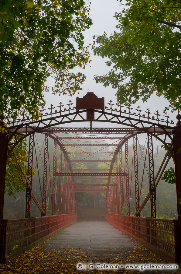
Potent remnants of classic New England are few and far between these days. Thousands of fields abandoned a century ago have returned to a natural state, bristling with woodlands where once there were croplands or rolling pastures. Mills that once clustered along the banks of streams in each village –grinding grain, cutting lumber, producing cider– have all vanished, along with a great deal of the dams and water wheels that animated their machinery. When it comes to covered bridges, there are still a few vestiges of the old days that remain, and these enduring icons of early infrastructure are the focus of my newest fine arts prints.
My collection, Old Timbered Crossings, is a series of three newly-released works, each featuring one of Connecticut’s authentic, historic covered bridges. From the moment I began considering this project, I knew that each bridge needed to be represented in a way that uniquely conveyed its character. I wanted to illuminate the rustic beauty that inspired 20th-century folks to take up the role of advocate and steward and push for these relics to be preserved and protected, even as the pressures of the modern world seemed to preclude their continued existence.
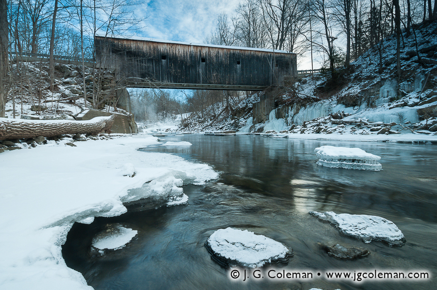
Roughly a year elapsed between the moment that I first began to consider the concept of Old Timbered Crossings to the winter day below Bull’s Bridge during which I completed the series. In that time, my interest in these bridges naturally grew deeper. I wasn’t only interested in their weathered siding and rural surroundings, but also in the culture and the long-lost way of life from which these resourceful structures emerged. These bridges, I discovered, are so much more than just old timbered crossings. For those that are receptive to their story, they are rare portals into a bygone era of New England. They serve as windows into the past, inviting us to reflect upon times when culture and daily life was simpler and more relaxed, but also toilsome and oftentimes unforgiving.
These covered bridges embody core elements of New England life: beauty, ingenuity and hardship. So although they may have outlived their era of functional relevance, they have emerged in modern times with a more enduring role, standing as potent reminders of who we are amidst a world in which it is so easy to lose ourselves.
A Look Back: Covered Bridges in Old Connecticut
Throughout most of the 1800s, covered bridges played an absolutely critical role in American transportation. Rivers needed to be crossed in order to haul goods to neighboring towns, get to church on Sunday or simply to travel from place to place for business, school and leisure. And in an era when durable metal components weren’t an option, the only way to make a long-lasting wooden bridge was to fit it with a roof to protect its structural timbers from the elements. So at any given time during the 1800s, there were untold dozens of covered bridges that dotted the state, spanning all manner of waterway from obscure brooks to the vast Connecticut River.
Although there may have been earlier examples, the first documented covered bridge in Connecticut was built in 1817 and spanned the Shetucket River between Norwich and Preston. It was washed away by spring floods just six years later, a scenario that would prove to be all too common for the roughly century-long reign of the covered bridge.
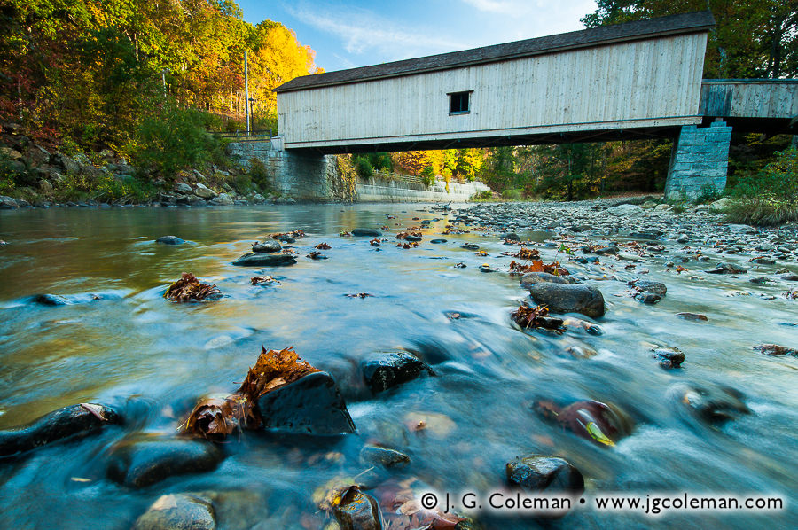
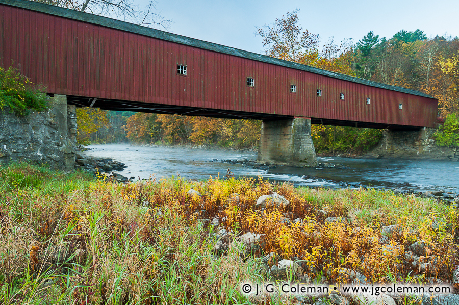
Only three of Connecticut’s authentic, 19th-century covered bridges have stayed with us into modern times. The West Cornwall Covered Bridge, built in the 1860s in Cornwall, and Bull’s Bridge, built in 1841 in Kent, both span the Housatonic River as it snakes through Connecticut’s Northwest Hills. Comstock Covered Bridge, built in 1873 over the Salmon River in East Hampton, is the last covered bridge in the eastern half of the state.
It’s only natural that we might wonder what ever became of the covered bridges that were once common sights throughout Connecticut. Why are there only three left if once there were several dozen? Even though some simply grew old and were decommissioned, their failures were oftentimes more spectacular. Two centuries worth of records seem to reveal that bridges most often succumbed to the very rivers and streams they spanned, being washed away during spring floods. Others were destroyed by ice dams, succumbed to fire or were ruined when mill dams broke upstream. It was not uncommon that a given bridge might be destroyed multiple times over just a decade or two, each time being rebuilt out of necessity. Not only was this quite costly, but these bridge failures also served to severely disrupt local travel. For about a century, though, the perennial hardship of covered bridge maintenance was simply accepted as a reality of New England life. The more advanced designs for covered bridges were even hailed as marvels of engineering.
All of that began to change in the mid-1800s as the burgeoning railroad system sought to cross Connecticut’s many rivers. Covered bridges simply couldn’t bear the enormous weight of locomotives and designers responded by engineering the first iron bridges, which offered significantly greater strength and durability than wood. Such bridges were initially too expensive for anything besides railroad projects, but it didn’t take long for more affordable designs to hit the market. All over the state, as wooden covered bridges built in the earlier half of 1800s collapsed or grew older and became unsafe, they were commonly supplanted by iron bridges that offered a greater carrying capacity and a much longer lifespan. By the 1870s, it was becoming increasingly rare for towns to invest in building new covered bridges in all but the most rural areas.
By the 1920s, Connecticut’s population had grown larger than ever and, with the ever-increasing ubiquity of the automobile, people were travelling much more frequently. New wooden bridges were no longer being constructed and the increased strain on infrastructure proved to be the final straw for many that had somehow managed to hold up into the 20th-century. What few covered bridges were left around this time would all mostly be gone within a couple decades. In some cases, collapsed or dilapidated bridges were not replaced, but simply decommissioned once and for all with traffic being forever re-routed to newer bridges nearby. Bridges that had carried traffic for two or three generations were suddenly erased from the map so thoroughly that, in modern times, you would never even know they had once stood there.
So while we may think of these rustic covered bridges as romantic anachronisms, the fact of the matter is that most Connecticut towns were probably quite relieved when, one by one, all of their high maintenance wooden bridges were replaced with considerably more durable structures. Even their aesthetics were often unappreciated; one Highway Engineer from Oregon wrote in a 1914 report that wooden covered bridges had many benefits, but listed among their downfalls that they “do not present a pleasing appearance”. In Connecticut, it wasn’t until mid-century that folks began to realize the swiftness with which covered bridges had all but vanished from the landscape. During the 1940s and 50s, for example, many older folks could probably still remember a time when their home towns relied upon covered bridges; their grandchildren, on the other hand, would already have thought of those wooden structures as novel antiques.
As part of J. G. Coleman’s Decor Series prints, all of the works seen here are available at Pixels.com. You are encouraged to visit J. G. Coleman’s Pixels Art Store, or see all of Fine Art America’s covered bridge art.
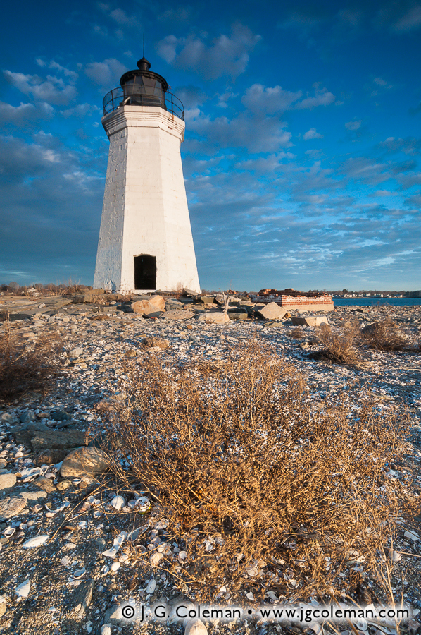
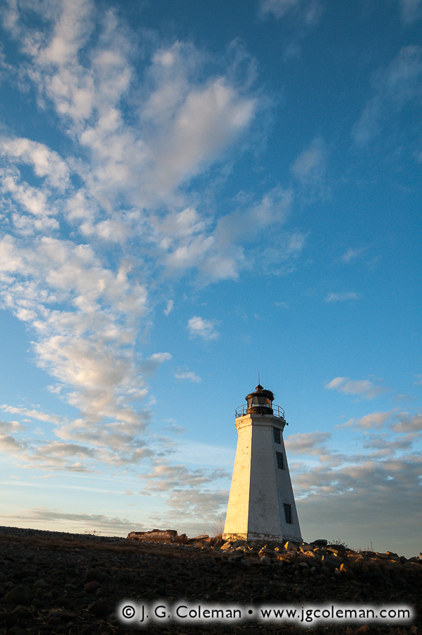
For nearly 200 years, the Black Rock Lighthouse has been perched upon Fayerweather Island just off the coast of Bridgeport, Connecticut, weathering countless hurricanes, blizzards, floods and even the tireless efforts of several generations of vandals. Against all odds, the Black Rock Light continues to watch over Long Island Sound to this very day, an enduring reminder of a bygone era of Connecticut maritime heritage.
This iconic lighthouse of the Bridgeport coastline is featured in my new pieces, Fayerweather Daybreak (above) and Black Rock Crescendo (below), both of which feature the white hexagonal tower against the glorious light of dawn. Indeed, the Black Rock Light is quite a rare gem, especially when we consider that so much of the view of Bridgeport’s coastline in this area includes industrial buildings and factory smokestacks.
It may be interesting to note that, even though the Black Rock Light is situated on Fayerweather Island, it is one of the few lighthouses left in Connecticut that is accessible by the public on foot. Most of Connecticut’s off-shore lighthouses were constructed upon islands that are relatively distant from the coast, but when the Black Rock Light was built upon Fayerweather Island in the earlier half the 19th-century, it was a mere 1000 feet from the mainland. In fact, folks could even walk to the island on a sandbar that would emerge during low-tide. By 1880s, the decision was made to build a large stone breakwater over the existing sandbar, permanently linking the island to the mainland even during high tide.
The new breakwater would surely have been appreciated by lighthouse keepers and maintenance crews who could now easily move back and forth between the island and mainland without the need for a boat. But in 1933, when the lighthouse was officially decommissioned and essentially left abandoned, the breakwater became an avenue for vandals that gutted and routinely defaced the structure while the ravages of time and environment took their toll. Mercifully, two efforts at restoration were eventually launched, one in the 1980s and the other in the 1990s, which succeeded at stabilizing and beautifying the decaying structure.
Unfortunately, even with the lighthouse now being part and parcel to Bridgeport’s Seaside Park, vandalism remains an on-going issue. During the shoot that I produced Fayerweather Daybreak and Black Rock Crescendo, for example, I found the walls of the lighthouse scribbled with all manner of graffiti which I decided to painstakingly edit out of my final images. The result is that the lighthouse you see in these works is a bit idealized, at least in the sense that it is shown in the context of world where folks might be inclined to respect this old sentinel of Black Rock Harbor rather using it as a personal billboard.
Luckily, if spray paint is the only problem that the Black Rock Light needs to contend with, it’s likely to fare exceptionally well. Upon its completion in 1823, the builders of the Black Rock Light claimed that it had been constructed to “withstand the storm of ages”… so far, it’s done exactly that.
As part of J. G. Coleman’s Decor Series prints, all of the works seen here are available at Fine Art America. You are encouraged to visit his J. G. Coleman’s Fine Art America eStore, or see all of Fine Art America’s connecticut art.
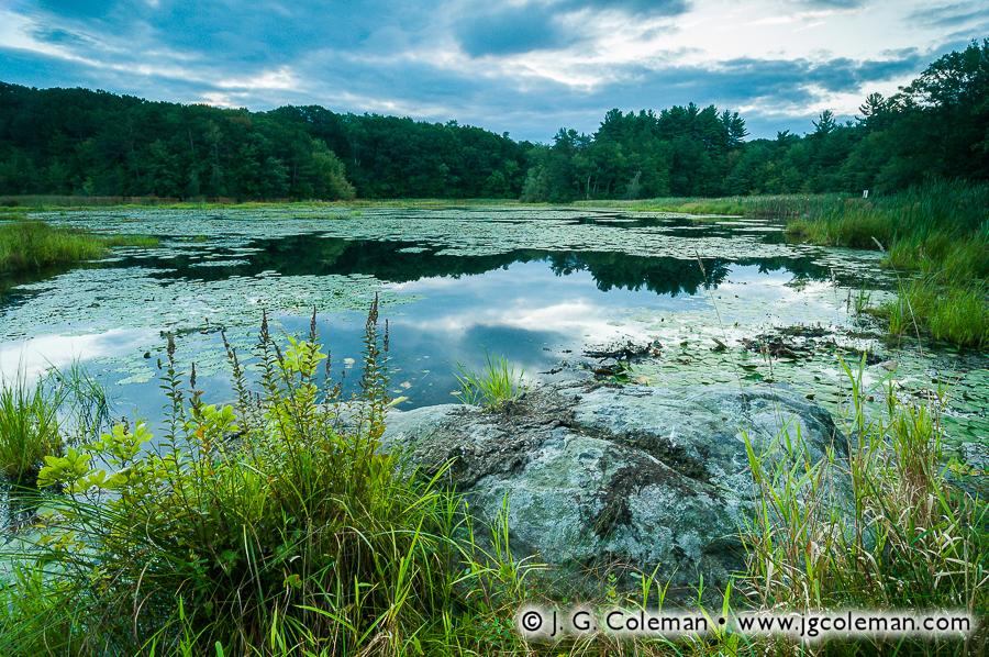
My new release this week, titled Juniper Hill Pondside, comes to you from Sperry Pond in the wooded northeastern corner of Middlebury, Connecticut. I learned of this small nature preserve not long after moving to Western Connecticut and I’ve since visited a few times throughout different seasons. On this particular morning in early September last year, I observed a beautifully moody display as the clouds sprawled across the sky over shadowy woodlands, reflecting from the mirror-like surface of Sperry Pond.
Juniper Hill Preserve was donated to the Middlebury Land Trust by Mark and Lem Sperry and certainly makes a handsome contribution to the town’s open spaces. The pond itself seems to be well on its way towards becoming more of a wetland than a proper pond, for aquatic plant life can be found crowding most of the surface by summertime. However, there’s no doubt that wildlife still manages to find plenty of habitat here. Hikers and nature lovers, for their own part, find a welcome respite at this quiet preserve on Sperry Pond.