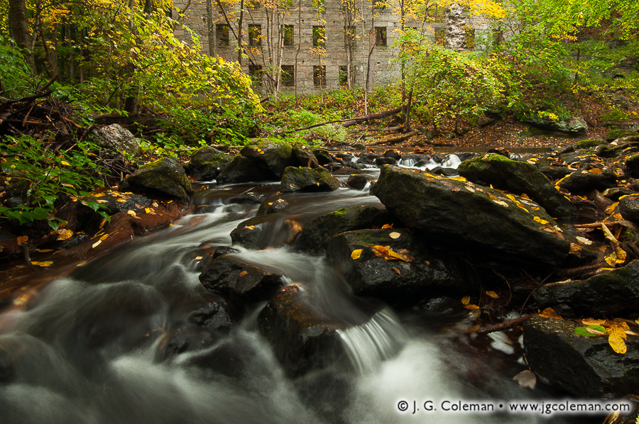
“Cotton Hollow Echoes”, one of my new pieces released this week, brings us to the shady depths of Glastonbury’s Cotton Hollow, where spirited cascades along Roaring Brook serenade the haunting, overgrown edifice of a long-abandoned mill.
There was a time when this stretch of Roaring Brook was the epicenter of South Glastonbury’s industrial might. From the 1700s onward, the river was lined with mills and factories that dammed the river, harnessing its strength to animate machinery. Cotton Hollow saw the production of everything from gun powder to boat anchors to its eponymous cotton textiles.
But times change; so does technology. Once modern electrical grids eliminated the need for industry to be tethered to rivers, the crowded mills along Roaring Brook were slowly silenced. Boulder dams were eventually toppled. Woodlands eagerly reclaimed the river. Today, a quiet nature preserve occupies the very riverbanks where throngs of mill workers once labored amidst a cacophony of frantic machinery.
Purchase a Fine Art Print or Inquire About Licensing
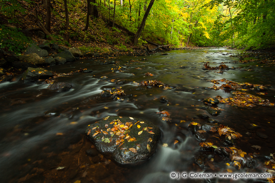
My latest work features the lively cascades and verdant woodland banks of the Hammonasset River, which forms the border between Madison and Killingworth as it courses south from Lake Hammonasset en route to Long Island Sound.
Along its northern stretches, the Hammonasset River is a modest, boulder-strewn brook with cool waters shaded by a dense forest canopy. Swirling pools, rips and riffles along its course are home to Connecticut’s only native trout: the brook trout. These fish are an important “indicator species” because their presence in a stream suggests that the water is sufficiently clean and cool; in short, that the habitat is in good shape. When the brook trout vanish, you can bet that major disturbances to the river ecosystem are to blame.
Oh, and just in case there was any doubt that brook trout still thrive in the Hammonasset, I was more than obliged to pull a fish from the very pool seen here in “Hammonasset Descending” this spring; an exquisite specimen, washed over with some incredible colors and patterning.
Purchase a Fine Art Print or Inquire About Licensing
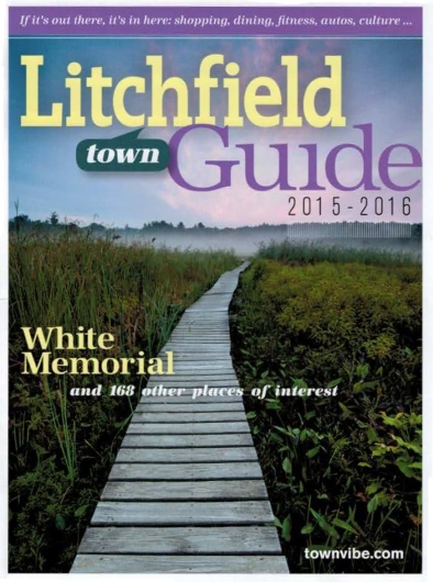
It’s particularly gratifying whenever I see my photography put to use in a publication, even more so when its placement is prominent. This year’s Litchfield Town Guide does just that, filling its cover with one of my pieces from the wildlands of Litchfield, Connecticut.
When I produced my piece, “Ethereal Passage”, in mid-August of 2012 on the boardwalks around Little Pond at the White Memorial Foundation, its cover-worthiness was the last thing on my mind. My only interest in that moment before dawn, as I stood beneath a sky painted with wisps of faintly luminous clouds, was to capture the weather-beaten boardwalk as it meandered its way through shadowy wetlands towards a whimsical vanishing point in the misty, silhouetted forest on the horizon. The shot came together exactly as I had envisioned.
And, as it would happen, “Ethereal Passage” was precisely what Litchfield Magazine had in mind when it began looking for a cover photograph for its 2015 town guide. As a directory of places-to-go and things-to-do in the lovely town of Litchfield, it’s only fitting that the sprawling, 4,000-acre nature preserve in town operated by the White Memorial Foundation would be the first thing readers see!
Purchase a Fine Art Print or Inquire About Licensing
My piece, “Salmon River Wildlands”, brings you to the wooded banks of the Salmon River as it meanders through Colchester, Connecticut en route to its confluence with the Connecticut River. Riffles and wisps of whitewater wrinkle the river’s surface, which gleams with reflections of early morning light.
There was a time —back in the earliest colonial era of New England— when the Salmon River’s namesake, Atlantic Salmon, could be seen heading upstream in droves to spawn each year during autumn. It would’ve been a spectacle every bit as impressive as the modern salmon runs of Alaska and Western Canada. But dam-building, among other pressures, delivered a death blow to the species, barricading hundreds of miles of streams and brooks and cutting salmon off from their ancient breeding grounds. Annual migrations that had occurred faithfully for thousands of years in Connecticut came to a grinding halt after barely more than a century of European settlement. The Connecticut River strain of Atlantic Salmon was extinct before 1800, preserved only in the name of a few rivers and brooks where they had once flourished.
Purchase a Fine Art Print or Inquire About Licensing
If you’ve read any number of my posts here on From the Field, you probably know that I get a bit nostalgic when it comes to thoughts of the “old days” of Connecticut. You know, the days before the railroads came through, before industry completely transformed the previous two centuries of ever-steady Yankee lifestyle; the days when the state was still a bucolic patchwork of small, quiet towns connected by rough carriage roads. While I’m well-aware that it’s dangerously easy to idealize those bygone days, overlooking the many hardships and inequalities that people of that era faced, I still find something deeply comforting in the thought of a time in Connecticut’s history when daily life didn’t move at the breakneck speeds to which we’ve become accustomed in modern times.
In the 1830s, the population density of Connecticut is estimated to have been only about 60 people per square mile, a far cry from the staggering 750 people per square mile that inhabit the state today. It is presently one of the most densely-populated states in the nation, coming in at fourth place behind New Jersey, Rhode Island and Massachusetts. Indeed, things have certainly changed over the last few centuries. But perhaps a visit to Northern New England gives us a faint taste of what the Nutmeg State might’ve been like 200 years ago.
Fair Haven, Vermont
Take, for example, my new piece titled “Bird Mountain Countryside”, which brings us to Fair Haven, Vermont. Here we are treated to a broad expanse of meadows and pastures that lead our eyes towards the horizon where the monolithic slopes of Bird Mountain rise from a thick blanket of early-morning fog.
The lands of Vermont seem practically deserted in comparison to most places in Connecticut. In fact, the population density of the “Green Mountain State” is less than 80 people per square mile in modern times, rather close to the figure reported for Connecticut so long ago during the pre-railroad era.
After I finished developing this piece, I took a proverbial “step back” and found that it faintly reminded me of the 1849 painting of New Haven’s West Rock Ridge by Frederic Edwin Church, a 19th-century Connecticut-born artist. I won’t indulge in likening myself to this master of the Hudson River School, but I mention Church’s painting because, like my “Bird Mountain Countryside”, it portrays a classic, bucolic foreground coming to a certain crescendo at a prominent mountain in the distance. "West Rock, New Haven" (1849) Painted by Frederic Edwin Church
The big difference here is that my perspective of Fair Haven is current; if you were to stand exactly where I produced this photograph, you’d see the same fields, pastures and meadows. In contrast, Church’s idyllic agrarian New Haven has long ago vanished beneath increased urbanization and, especially, the concomitant phenomenon of suburban sprawl along city margins. In fact, the Hudson River School painters were known to “idealize” the otherwise real landscapes that they painted… so it’s tough to say if Church’s New Haven of 1849 actually even existed as he painted it. Maybe it did, but maybe there’s a measure of fiction blended into his portrayal. We may never really know for sure…
Ultimately, the point remains that what Church was trying to express in his “West Rock” -that is, an image of an agrarian society peacefully co-existing with nature- isn’t far from the reality that exists in modern times at the foot of Bird Mountain. Perhaps it is that the character of “Old Connecticut” is in some sense still alive within the valleys of the Green Mountains.
Killington, Vermont
Our next few destinations on this odyssey are within the town of Killington, Vermont… a place which is undoubtedly famous among Northeastern skiing enthusiasts. However, my latest works from Killington were produced in the warm, humid months of summer… long after the snow drifts had vanished. Indeed, the side of Killington I want to show you is little-known to those who arrive for a few days in the dead of winter and never leave the vicinity of the resort. If we venture elsewhere within the 46 square miles of territory the town encompasses, we find some rather beautiful places that lay off the beaten path.
“Mirror of the Shrouded Hills” (below), my new piece from Killington’s Kent Pond, features one of those scenic treasures. Here we find ourselves overlooking a landscape crowned by thickly-wooded hills and steeped in heavy blankets of lingering mist. Below, the hills are cast from the surface of Kent Pond as a soft reflection, out of which emerges the shadowy silhouette of a small, rocky island populated by only a few lonely conifers seemingly marooned from the surrounding forests.
What originally drew me to Kent Pond, though, was the outlet brook that departs from the body of water on its eastern shores. Some official maps call this stream “Kent Brook”, a name which is as sensible as it is unremarkable. Unofficially, this brook enjoys a much more interesting title: “Thundering Brook”. At the risk of exposing my childishly-excitable side, I will admit that any river called “Thundering Brook” is a river that I simply must see for myself.
My fine art piece, “Green Mountain Riverscape”, portrays a conifer-crowded glade scattered with boulders where Thundering Brook topples over tiers of terraced bedrock before disappearing some distance downhill. This piece was especially gratifying to produce, as I feel that I was able to faithfully capture the very wild and untamed aura that permeates the landscape surrounding the rugged watercourse of Thundering Brook.
“Green Mountain Riverscape” is, in a sense, a timeless vision of Vermont’s natural places, freed of any strict associations with modern times. As I look at the piece I wonder,” Could Thundering Brook really have looked much different 100 years ago? Or 200 years ago? Even 1,000 years ago?” Ordinarily, I dive deeply into the history of the landscapes that I photograph, for I feel strongly that understanding the history of a place brings me closer to its essence. But occasionally I am moved to forgo this craving for knowledge. This vista on Thundering Brook is not far from a well-packed dirt road… beside the brook runs a small-diameter pipeline of indeterminate use… and beside portions of the brook, the banks are well-packed by frequent visitors. But for all of these reminders of the modern world that surround Thundering Brook, there were inevitably instances in which I gazed in just the right direction from just the right perspective and, all of the sudden, it was as if I was looking not only at a river that receded into the distance, but also at a scene that receded deep into the past… so deeply that, for a brief moment, it was as if all the pesky considerations and attachments to clock and calendar, which are so much a part of our modern lives, vanished amongst the cacophony of cascades and waterfalls.
The calming waters of Thundering Brook, as they are seen in “Green Mountain Riverscape”, may not appear to be as furious… as violent… as “thundering”… as one might expect. I’ll admit that Thundering Brook was not exactly a roaring torrent on the day that I visited, a condition that I attribute mostly to the peculiar dry spell that dominated most of New England’s summer season. Every brook I visited this year, from Southern Connecticut to Central Vermont to Eastern New York, was generally at quite a reduced water volume. But given the circumstances, Thundering Brook still had a decent volume of water flowing; I can only imagine that it truly thunders during the springtime, angrily crashing through the forests of Killington as it hauls away meltwater. One source* states that Thundering Brook carries less than 10 cubic feet of water per second (cfs) in the summertime, but notes that “peak events” have seen that figure swell to a staggering volume of just under 800 cfs! Can you imagine the near-cataclysmic power being channeled through this brook?
But even if Thundering Brook was lacking the water volume required to truly live up to its name, the impressive waterfalls along its course were still quite spectacular. “Thundering Brook Falls”, a series of roughly three big drops along the course of Thundering Brook, were the first landmarks that really sparked my interest to conduct a shoot in Killington.
My new piece, “Parallel Worlds”, features the final and tallest waterfall of the bunch. What I found especially intriguing about the views of this 60-foot waterfall was the unusual contrast between the forest and the watercourse. Owing to the green-tinted light filtering through the coniferous canopy, the entire forest in the upper portion of the frame is steeped in warm color tones and the underlying rock is softened by lush carpets of moss. Yet, at the foot of the woodlands we find Thundering Brook Falls cascading over slopes of barren bedrock, jagged and angular and glistening with subtle reflections of the sky above. “Parallel Worlds” leverages this intriguing disparity, inviting us to simultaneously accept nature as both vital and desolate… a source of nurture and a force of hardship. Through the lens of civilization, nature seems to express itself alternately as the giver and taker. There on Thundering Brook Falls, though, these parallel worlds blended seamlessly into a landscape that tapped a more primeval vein of my unconscious. And as I sat by the gorge in the humid early-morning air, the Sun triumphantly breaking through the clouds and casting bright beams upon the woodlands, I was reminded of the words of John Muir: “The clearest way into the Universe is through a forest wilderness.”
To see larger versions of the Vermont landscapes pictured here, simply click on any of the photographs above and you’ll be brought to my online gallery.
To see all of my landscape work from Vermont, be sure to visit my Vermont Gallery at JGCOLEMAN.COM.
* Information on water volume was drawn from the profile for Thundering Brook Falls found on Waterfalls of the Northeastern United States, a website authored by Dean Goss. Be sure to check out his page for Thundering Brook Falls.
You can be among the first to see J. G. Coleman’s print, “Old Dish Mill Falls on Jim Brook“, a fine-art landscape photograph taken at Roaring Brook Nature Center in Canton, Connecticut. The work will be on display through the month of November at J. Vallee Brunelle Fine Art & Framing in Granby, Connecticut. “Old Dish Mill Falls on Jim Brook” is only one of many works that will be on display for Celebrating Art in Nature, the 2011 Granby Land Trust Annual Juried Art Show.
Celebrating Art in Nature is a small art show that features paintings, drawings, photography and 3D works inspired by nature and landscapes of the Farmington River Valley region. The opening reception for the showing is on Thursday, November 3, 2011 between 5:00 PM and 8:00 PM.
The showing will run from November 3, 2011 through December 1, 2011 and every piece on display is available for purchase. The Granby Land Trust will receive 40% of the proceeds for every work purchased at J. Vallee Brunelle, which will help them continue to preserve Granby’s natural heritage (a portion of those proceeds will also go towards supporting the event).


")