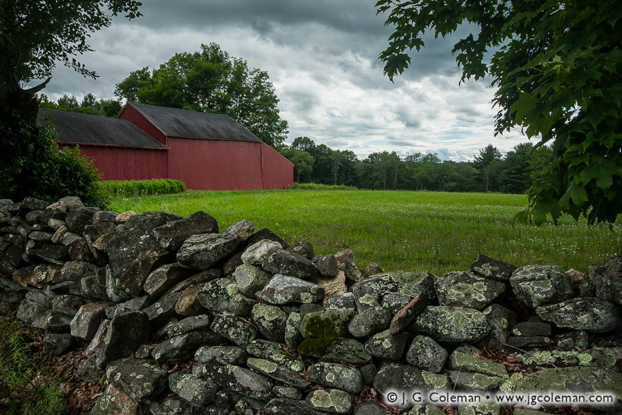
“Yankee Farmlands № 31” is the latest installment in an on-going project of mine in which I celebrate the agricultural heritage of New England through the scenic farmlands of Connecticut. This time around, we find ourselves in the small town of Bolton, peering at a barn and forest-bound meadow over the lichen-encrusted rocks of an iconic fieldstone wall.
Most of New England’s fieldstone walls were built 150 to 200 years ago during an era in which an ever-growing population was feverishly clearing new farmland. Exhausting labor went into constructing these walls as untold tons of stone were plucked from the upper layers of soil, hauled off to the outskirts of the pasture or field and loosely stacked by hand.
These relict stone walls are celebrated for their rustic aesthetic these days, but we might be surprised to discover that they were considered rather mundane at the time of their construction. For the Yankee farmers that built them, fieldstone walls merely represented a practical way to dispose of agricultural refuse. It wasn’t until the 20th-century, when much of New England’s age-old agrarian ways had faded, that rustic stone walls became romantic relics of a simpler, unhurried era in the region’s history.
Purchase a Fine Art Print or Inquire About Licensing
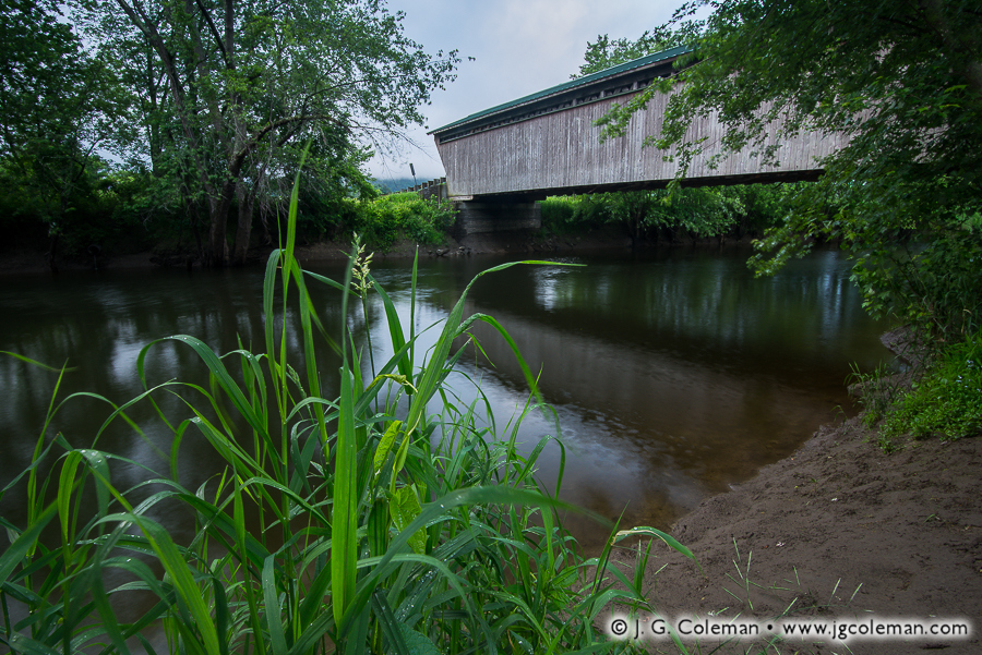
As I stood upon a muddy riverbank during a warm spring morning in Vermont’s Rutland County, I watched reflections of the weathered Goreham Bridge ripple upon Otter Creek beneath a hazy sky streaked with broad, indistinct swaths of luminous blues. My piece, “Goreham’s Crossing at Pittsford”, emerged from that moment and brings together several elements which elaborate upon the sense of place wrapped up in this rustic riverscape in the Green Mountain State.
Built in 1842 and carrying traffic to this day, Goreham Bridge is one of four 19th-century covered bridges remaining in the rural town of Pittsford. That’s no small feat when you consider that the entire state of Connecticut has only three! But the town of Montgomery, about 100 miles north near the Canadian border, can justifiably be called Vermont’s “covered bridge capital”. Remarkably, seven covered bridges are scattered across the township’s 56 square miles.
Purchase a Fine Art Print or Inquire About Licensing
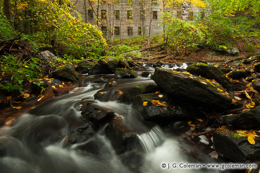
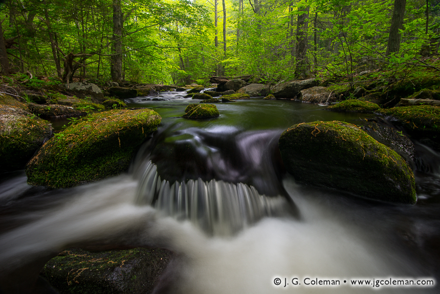
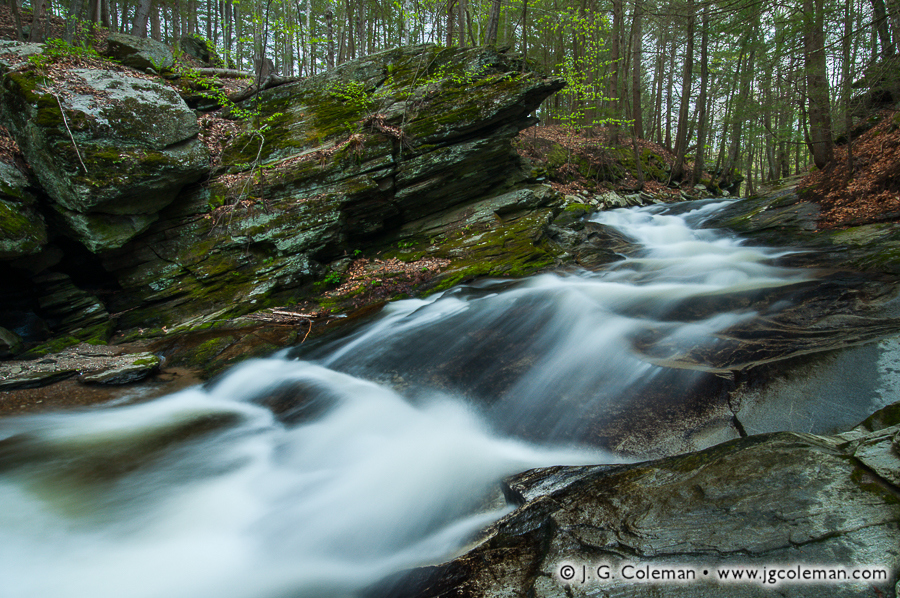
“Cotton Hollow Echoes”, one of my new pieces released this week, brings us to the shady depths of Glastonbury’s Cotton Hollow, where spirited cascades along Roaring Brook serenade the haunting, overgrown edifice of a long-abandoned mill.
There was a time when this stretch of Roaring Brook was the epicenter of South Glastonbury’s industrial might. From the 1700s onward, the river was lined with mills and factories that dammed the river, harnessing its strength to animate machinery. Cotton Hollow saw the production of everything from gun powder to boat anchors to its eponymous cotton textiles.
But times change; so does technology. Once modern electrical grids eliminated the need for industry to be tethered to rivers, the crowded mills along Roaring Brook were slowly silenced. Boulder dams were eventually toppled. Woodlands eagerly reclaimed the river. Today, a quiet nature preserve occupies the very riverbanks where throngs of mill workers once labored amidst a cacophony of frantic machinery.
Purchase a Fine Art Print or Inquire About Licensing
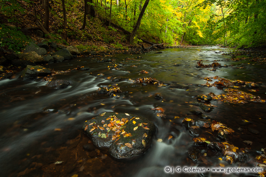
My latest work features the lively cascades and verdant woodland banks of the Hammonasset River, which forms the border between Madison and Killingworth as it courses south from Lake Hammonasset en route to Long Island Sound.
Along its northern stretches, the Hammonasset River is a modest, boulder-strewn brook with cool waters shaded by a dense forest canopy. Swirling pools, rips and riffles along its course are home to Connecticut’s only native trout: the brook trout. These fish are an important “indicator species” because their presence in a stream suggests that the water is sufficiently clean and cool; in short, that the habitat is in good shape. When the brook trout vanish, you can bet that major disturbances to the river ecosystem are to blame.
Oh, and just in case there was any doubt that brook trout still thrive in the Hammonasset, I was more than obliged to pull a fish from the very pool seen here in “Hammonasset Descending” this spring; an exquisite specimen, washed over with some incredible colors and patterning.
Purchase a Fine Art Print or Inquire About Licensing
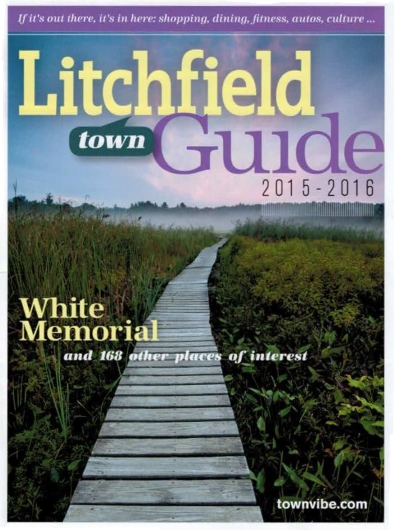
It’s particularly gratifying whenever I see my photography put to use in a publication, even more so when its placement is prominent. This year’s Litchfield Town Guide does just that, filling its cover with one of my pieces from the wildlands of Litchfield, Connecticut.
When I produced my piece, “Ethereal Passage”, in mid-August of 2012 on the boardwalks around Little Pond at the White Memorial Foundation, its cover-worthiness was the last thing on my mind. My only interest in that moment before dawn, as I stood beneath a sky painted with wisps of faintly luminous clouds, was to capture the weather-beaten boardwalk as it meandered its way through shadowy wetlands towards a whimsical vanishing point in the misty, silhouetted forest on the horizon. The shot came together exactly as I had envisioned.
And, as it would happen, “Ethereal Passage” was precisely what Litchfield Magazine had in mind when it began looking for a cover photograph for its 2015 town guide. As a directory of places-to-go and things-to-do in the lovely town of Litchfield, it’s only fitting that the sprawling, 4,000-acre nature preserve in town operated by the White Memorial Foundation would be the first thing readers see!
Purchase a Fine Art Print or Inquire About Licensing
My piece, “Salmon River Wildlands”, brings you to the wooded banks of the Salmon River as it meanders through Colchester, Connecticut en route to its confluence with the Connecticut River. Riffles and wisps of whitewater wrinkle the river’s surface, which gleams with reflections of early morning light.
There was a time —back in the earliest colonial era of New England— when the Salmon River’s namesake, Atlantic Salmon, could be seen heading upstream in droves to spawn each year during autumn. It would’ve been a spectacle every bit as impressive as the modern salmon runs of Alaska and Western Canada. But dam-building, among other pressures, delivered a death blow to the species, barricading hundreds of miles of streams and brooks and cutting salmon off from their ancient breeding grounds. Annual migrations that had occurred faithfully for thousands of years in Connecticut came to a grinding halt after barely more than a century of European settlement. The Connecticut River strain of Atlantic Salmon was extinct before 1800, preserved only in the name of a few rivers and brooks where they had once flourished.
Purchase a Fine Art Print or Inquire About Licensing
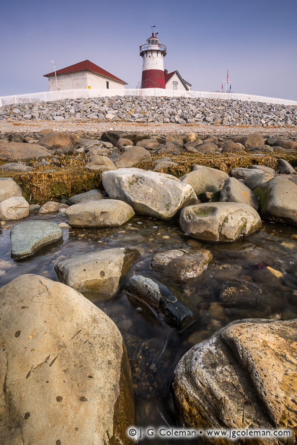
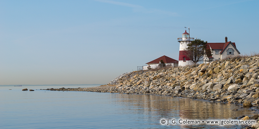
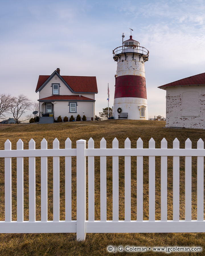
In my new piece, “Judson’s Post”, I bring you to the shores of Long Island Sound where calm waters lap at boulders in the shallows. Facing inland, we see the Stratford Point Lighthouse standing tall upon the distant hill behind a seawall of piled rip-rap and a white picket fence. Although the current Stratford Point Light was guiding sailors near the mouth of the Housatonic River since the late 1800s, the history of Stratford Point as the site of a maritime beacon stretches back much further.
Stone and metal lighthouses generally came about beginning in the early 1800s, replacing a generation of earlier wooden lighthouses that had been built during the later 1700s. But colonists and merchants had been navigating the New England coast since the early 1600s and, in an era before lighthouses, they too needed some means of avoiding coastline hazards or locating harbors from afar.
During the earliest colonial years, a great bonfire was lit on Stratford Point during foggy nights whenever a ship was expected to arrive. At some point, an iron hearth was attached to the top of a tall post, elevating the fire above ground level for increased visibility. It wasn’t until 1822 that a true, 28-foot wooden lighthouse was built on Stratford Point. And if that sounds like a long time ago, recall that the settlement of Stratford was already almost two centuries old at that point. The current cast-iron tower replaced the decaying wooden lighthouse in 1880 and has stood on Stratford Point ever since.
I titled “Judson’s Post” (photo at top) in honor of Theodore Judson, who was in his early 30s when he assumed the duty of lighthouse keeper at Stratford Point in 1880. He was just shy of age 70 when he finally retired in 1919, having manned the lighthouse for almost four decades. A truly impressive run by anyone’s standards!
Purchase a Fine Art Print or Inquire About Licensing
With over 3,800 people per square mile, the crowded city of Waterbury in Western Connecticut is among the last places you might expect to find natural beauty. Don’t count it out entirely, though: the calm waters and wooded hills of Great Brook Reservoir on the east side of the city, seen here in my piece “Lakewood Shimmering”, are a welcome escape from the concrete, brick and asphalt.
It’s hard to imagine that when Waterbury was settled by Europeans in the late 1600s, the Central Naugatuck Valley was still a vast frontier of wooded hills. In fact, townspeople referred to the settlement by its Native American name, “Mattatuck”, for the first decade of its existence.
Waterbury’s rocky landscape made for terrible farmland and the town’s growth stagnated for a century. When brass manufacturing took off in the 1800s, though, Waterbury became an industrial powerhouse —the “Brass City”— and began to grow rapidly.
Purchase a Fine Art Print or Inquire About Licensing
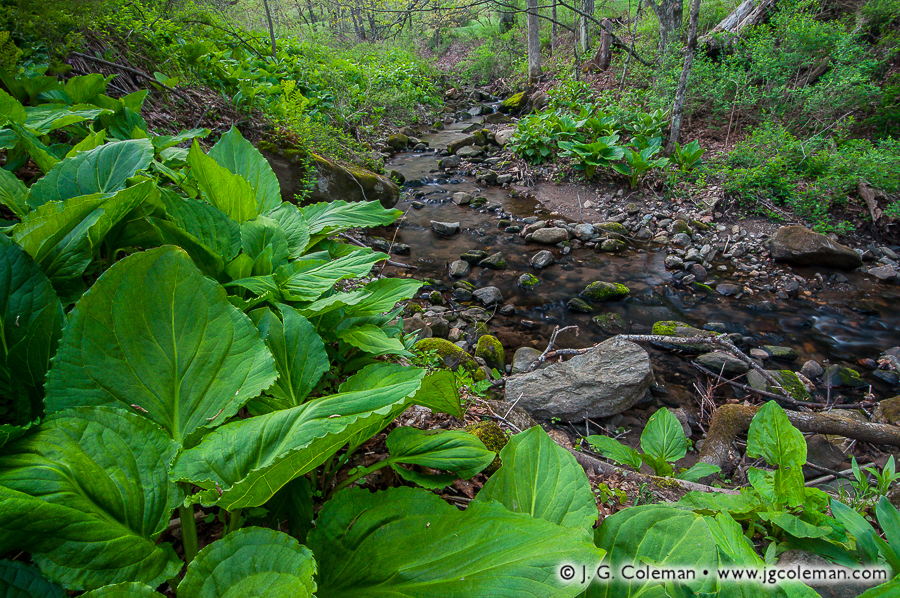
My new release from the Brian E. Tierney Preserve, “Tierney Springtime”, brings you into the wooded hills of Roxbury in Western Connecticut. Jack’s Brook, a lively tributary of the Shepaug River, is found snaking through a rock-strewn glen in the faint morning twilight as broad, verdant leaves of riverside skunk cabbage jostle in the breeze.
Although the lush greenery of skunk cabbage is a refreshing sign of spring, anybody that has traipsed through patches of this plant in the wetlands as a child is all too familiar with the potent stench of its sap. That foul odor, not surprisingly, inspired the comparison to the rank odor unleashed by frightened skunks. Luckily, the stench of skunk cabbage isn’t quite as noxious and doesn’t linger nearly as long as that of an actual skunk, but it’s unpleasant just the same.
In spite of its unfortunate reputation, eastern skunk cabbage is actually a quite remarkable plant which is expertly adapted to the climatic extremes of New England. Beginning as early as January and February, the mottled flower hoods of skunk cabbage can be found melting through the snow and ice on their wetland habitat. That’s right: skunk cabbage is one of the rare plants that is able to generate it’s own heat, sometimes in excess of 20° to 30°F above that of the surrounding air. This incredible ability affords it the opportunity to push its flowers up in late winter in order to draw pollinating insects before its competitors have so much as sprouted. And believe it or not, even that offensive odor serves a very clever purpose. Since the smell roughly resembles that of rotting plants and animals, it attracts flies and similar insects that emerge very early in the year and pollinate the flowers of the skunk cabbage.
But truth be told, finding this natural garden of springtime foliage was actually just a welcome bonus along the route to my planned destination. The sight that had drawn me out to Tierney Preserve to begin with was a waterfall locally known as The Cascades which was mentioned in Russell Dunn’s book, Connecticut Waterfalls: A Guide. He had opted to prepend that generic name with the name of the brook upon which the 15-foot falls are formed, thus making them Jack’s Brook Cascades. You can see this waterfall in my new piece, “The Falls at Tierney” (above), where they weave through a rocky, woodland gorge in the faint morning light filtering down through the springtime canopy.
From a purely technical perspective, the waterfall really is more of a steep, spirited cascade. But I can understand why Dunn included it in his waterfall guide, since Jack’s Brook Cascades are every bit a waterfall by aesthetic standards. That is to say, it simply feels like a waterfall. Suffice it to say, you can expect to see “The Falls at Tierney” added to my ever-growing Waterfalls of Connecticut collection, which I urge you to check out at connecticutfalls.com if you haven’t visited lately. I’ve added a few more waterfalls over the course of the past season, so you’ll probably find something new.
Purchase a Fine Art Print or Inquire About Licensing
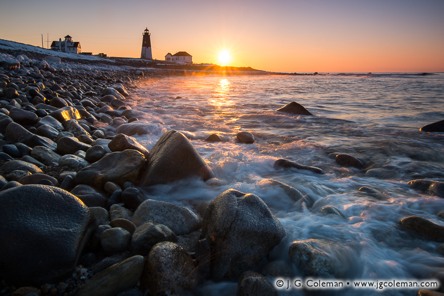
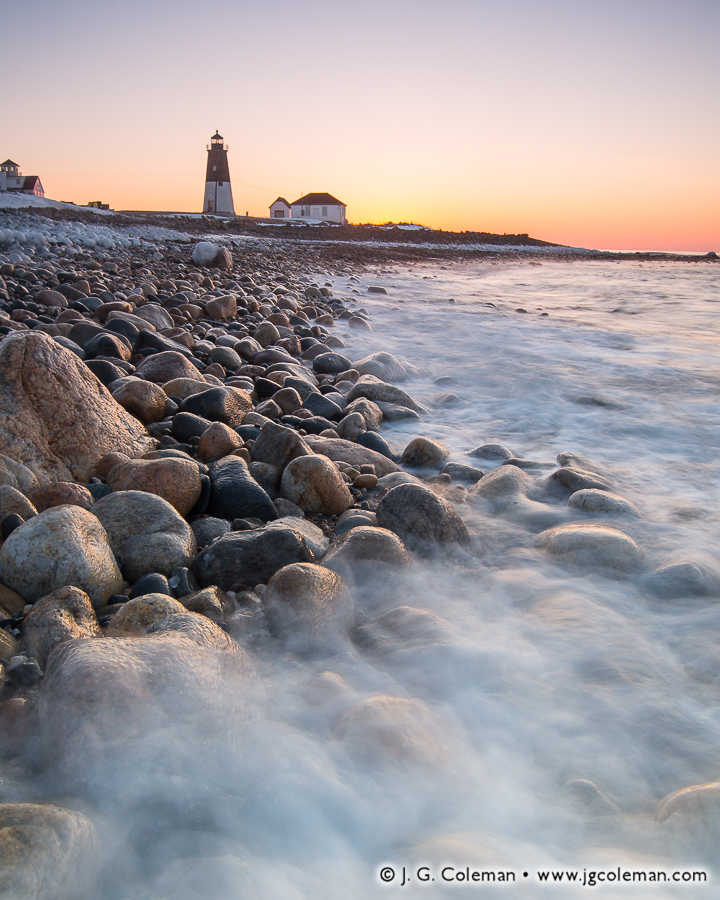
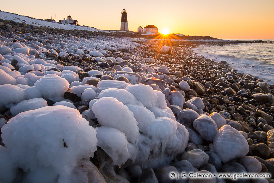
When I saw some images of the Point Judith Lighthouse come through on the Instagram feed of another Connecticut-based photographer earlier this year, my reaction was immediate: “I need to go there!” But as if the scenery wasn’t going to be exquisite enough, the location of the Point Judith Lighthouse at the mouth of Rhode Island’s Narragansett Bay made this shoot even more exciting. Why? Despite the fact that Rhode Island is a neighboring state, and was for some number of years only about an hour’s drive away (I live a bit further away now), I had somehow never taken a single photograph there. And it isn’t as if I was intentionally avoiding the ol’ Ocean State. I suppose that I was just preoccupied with other subjects over the years; meanwhile, Rhode Island and all of its compact beauty somehow managed to slip through the cracks. That was all going to change with the Point Judith Lighthouse.
When I selected a date in February for the shoot, I entirely expected that it would be cold. What I could not have imagined was that the thermometer on my dash cluster would read -5°F as I headed east and crossed over the Connecticut border in the frigid darkness before dawn. I had planned for the worst, though, and was decked out from head to toe in three layers. Furthermore, I knew the oppressive winter temperature was just as much of a blessing as a curse: it was a pretty sure bet that I would have Point Judith entirely to myself.
Indeed, there wasn’t a soul to be found when I parked my car at the end of the windswept peninsula. And even though I had done some measure of research ahead of my visit, the scenery at Point Judith proved to be even more exciting than I could have imagined. Take, for example, the beautifully-smoothed boulders piled upon the shoreline in my pieces “Dawn on Point Judith” (at top) and “Narragansett Shores II” (above). Strange as it may seem, there just aren’t beaches that look quite like that in Connecticut.
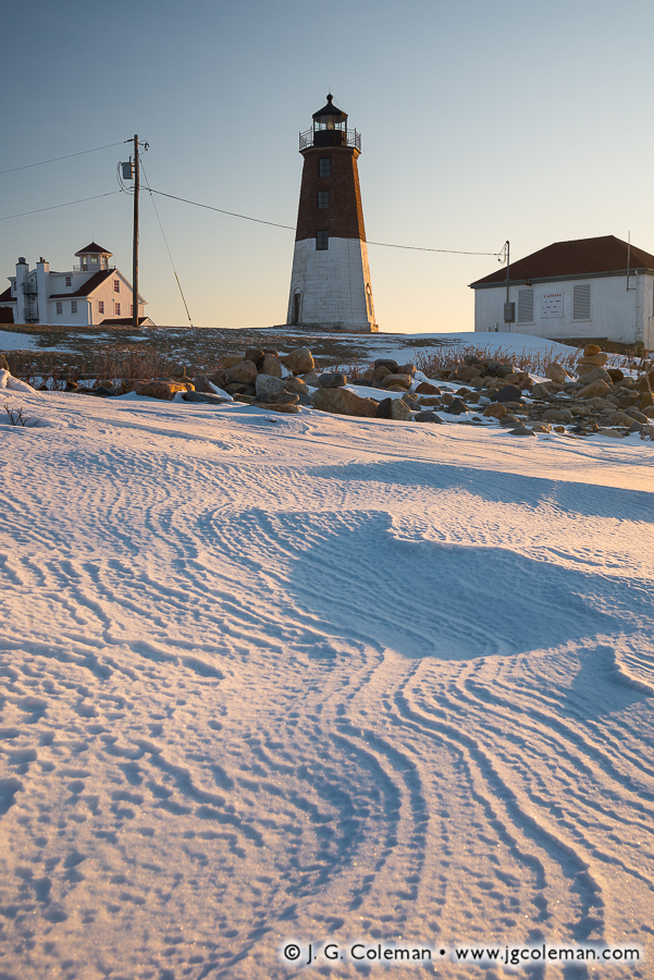
The Point Judith Lighthouse stands upon the distant horizon in those photographs, but plays a more prominent role in the composition of “Point Judith Wintertide” (above). In this piece, wind-carved grooves in the snow weave through the beachfront beside the tower and the coastal landscape is steeped in the warm colors of dawn. Despite being over 150 years old and having guided seafarers for some six generations, the venerable Point Judith Lighthouse is well-maintained and practically looks as if it had been built less than a decade ago. In an era when tight government budgets can sometimes result in historic lighthouses decaying or being shortsightedly off-loaded to private parties (and lost to the public forever), its refreshing to see that the lighthouse at Point Judith features a level of care and accessibility that is befitting of an age-old maritime relic.
Just how important was the Point Judith Lighthouse in the hey-day of New England’s maritime era? Between June 1871 and June 1872, for example, the keeper at Point Judith kept a tally of every vessel that passed the Point: the final count exceeded 37,000! So although shipwrecks did still occur occasionally off Point Judith, sailors navigating in the vicinity were statistically rather safe thanks to the presence of this wisely-positioned navigational aid.
Oh, did I mention that it was pretty damn cold out there? “Sweet Dawn, Bitter Cold” (above) sums it all up. Only about a dozen feet from the breaking waves, these seashore boulders were glazed with a thick, smooth shell of opaque ice. To be at Point Judith on that February morning at dawn, seeing it entombed in snow and ice and raked by frigid winds blowing in from the Atlantic, I certainly found a renewed appreciation for the brutal elements endured by the mariners of old.
Purchase a Fine Art Print or Inquire About Licensing
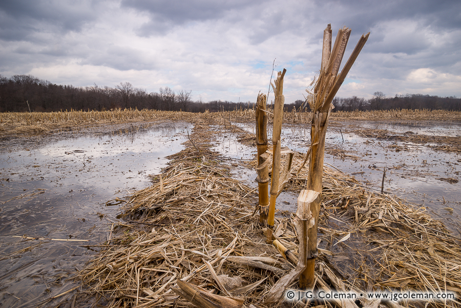
My latest addition to the Yankee Farmlands collection brings us to the town of Bloomfield in Northern Connecticut, where the broken stalks from last year’s corn crop stand in a field which has nearly flooded as warm spells melt away the thick snow pack.
“Mud Season” is the not-too-affectionate term for this time of year in New England. It’s that month-long stretch beginning in late March when the snows are melting away even though the soil below the surface of the ground remains frozen. Meltwater can’t drain through the icy underlayer, so it becomes trapped at the surface and produces a thick slurry of mud.
This was a major source of difficulty in the old days before most of Connecticut’s roads were paved. Horses, wagon wheels and even early cars would get swallowed up in the deep, rutted mud of dirt roads. The resulting mess perennially had a significant impact upon travel in the early springtime. Even still, we here in Southern New England have always had it easier than our neighbors further north. Mud season is far worse in Northern New England, where lower temperatures can freeze the ground much more deeply and springtime mud can hang around well into June!
On a different note, the particular swath of cropland shown here in “Yankee Farmlands № 26” may look like a rather ordinary corn field. But you won’t find any barns or a family farmhouse on this property, because the land is actually owned by the State of Connecticut. This stretch of flatland is a large, designated flood control area nestled amidst the mostly suburban landscape of Bloomfield. Although full-blown floods don’t occur here very often, setting aside this low-lying, poorly-drained area helps protect against unwise development and comes with accompanying benefit of preserving open space. Although I suppose that the state government might grow its own corn here for one reason or another, it seems much more likely that the land is leased to a local farmer who lives off-site and works it as remote field in addition to his or her other land.
Purchase a Fine Art Print or Inquire About Licensing
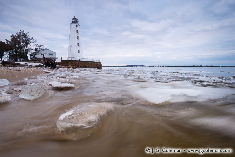
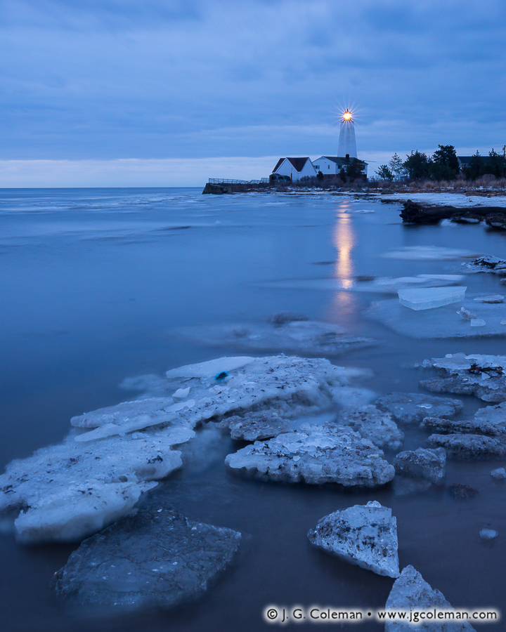
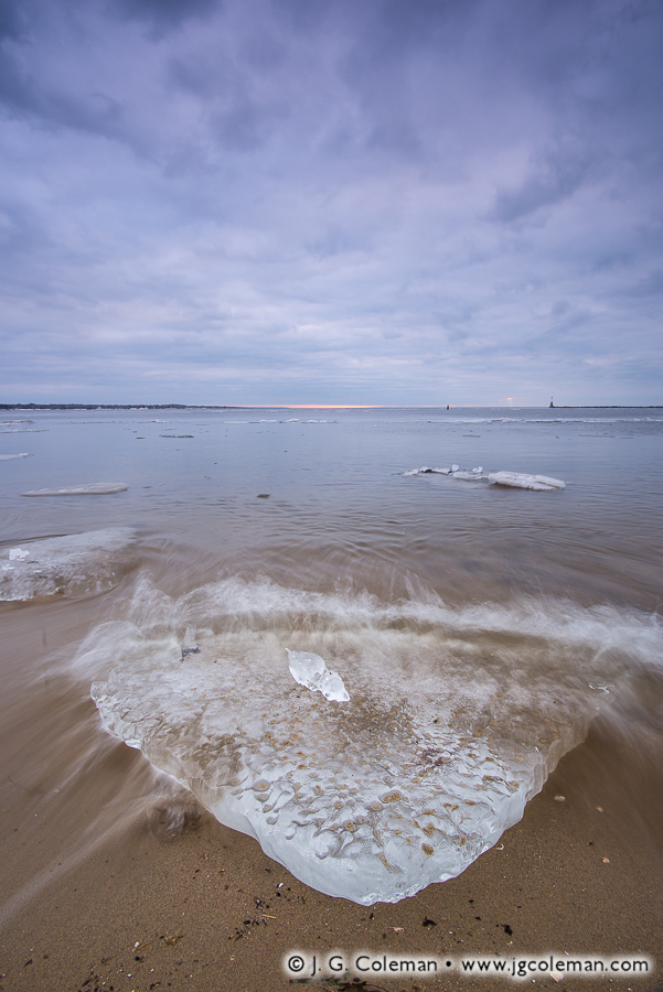
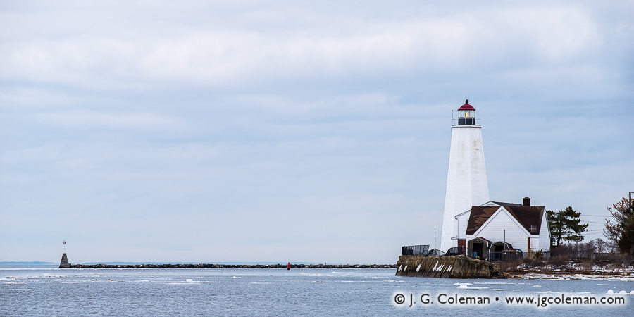
In my new piece “Lynde Point Seascape” (above), the Lynde Point Lighthouse stands sentinel on Long Island Sound at the mouth of the Connecticut River, its column of neatly stacked windows peering towards the sea from a 65-foot brownstone tower. Foreboding clouds loom overhead, while large slabs of wave-thrown ice batter the nearby seashore.
This is just one of my newly-released works featuring the stately Lynde Point Lighthouse in the context of a frigid New England winter. Built in 1838 to replace an older, dilapidated wooden tower, the present beacon at Lynde Point has remained an active aid to maritime navigation for more than a century and half, even as the land surrounding it transitioned from farms and pastures to lightly-wooded suburbs and sizable beachfront cottages.
But just as captivating as the lighthouse during my visit were the chunks of ice drifting on the waves and settling upon the seashore. From jewel-like bits to massive slabs more than 10 feet across, these bergs drifted down the Connecticut River from the state’s interior, only to quickly wash up on the seashores at either side of the river’s mouth.
Days tossing about in the ocean water left some of the ice slabs beautifully polished, their burrs and edges having melted away to reveal a smooth, glassy finish which glistened even in the faint light filtering down through the heavy morning clouds.
As you can see in my panoramic piece, “Saybrook Vista”, the conditions on this particular morning didn’t exactly offer stunning sunrise colors or dramatic side-lighting. Instead, I was offered some moody, exquisitely-textured cloud cover and only the faint, cool-toned light that was able to filter through. Sure… it’s not the sort of glorious morning that makes you want to lay out a beach towel and stay the afternoon. Then again, would we really expect that sort of idyllic day in late Winter? This is true New England in all of its elemental glory; these are the somber, overcast skies and cold, wind-swept beaches that were part of everyday life for Connecticut mariners of old.
Purchase a Fine Art Print or Inquire About Licensing