Categories
All Things Connecticut New Print Releases The American Northeast

Farewell Winter!

Yankee Farmlands № 25 (Glastonbury, Connecticut, USA)
“Yankee Farmlands № 25”
Glastonbury, Connecticut
© 2015 J. G. Coleman

Springtime in the American Northeast was described perfectly by Pennsylvania-born author Henry van Dyke in 1899:

“The first day of spring is one thing, and the first spring day is another. The difference between them is sometimes as great as a month.”

Judging by the stillness in the cold air and the snowpack lingering upon the barnyard of the Glastonbury farm in my new piece, “Yankee Farmlands № 25” (above), it would be tough to tell that a season of renewed warmth is upon us. Then again, fields that were covered a yard-deep in snow just a month ago have since thinned out to less than a foot and we’ve had some forgiving temperatures lately.

This much-awaited break in the winter weather is already presenting some fresh new shooting opportunities. Recent warm spells have melted substantial amounts of snow, causing brooks and rivers all over the state to swell. Waterfalls which have been snow-caked and encrusted with ice since January are finally awakening from their seasonal slumber. The woodlands and farmlands alike are still fairly dormant this early in the year, but as snow vanishes from road shoulders and trailhead parking lots, I’ve been delighted to find that I’ve finally got a place to park my truck again!

I’ve eased my cabin fever over these past couple months by putting together a new list of exciting shooting locations in Southern New England; I’m more than eager to get back out into a lively green landscape! So here’s to another long winter being behind us… and another glorious spring ahead!

Purchase a Fine Art Print or Inquire About Licensing

Click here to visit my the landing page for “Yankee Farmlands № 25” to buy a beautiful fine art print or inquire about rights-managed licensing for this image.

Want to See More?

Be sure to check out my Yankee Farmlands collection, the fruit of an on-going project which celebrates the agricultural heritage of the American Northeast through the breath-taking farmlands of Connecticut.

Categories
All Things Connecticut New Print Releases The American Northeast

Heart of the Old Mill

Heart of the Old Mill (Mill Pond Falls, Mill Pond Park, Newington, Connecticut)
“Heart of the Old Mill”
Mill Pond Falls on Mill Brook, Mill Pond Park, Newington, Connecticut
© 2015 J. G. Coleman

In my new piece, “Heart of the Old Mill”, Mill Pond Falls slips over a shadow-cloaked ledge, its frigid cascades churning to whitewater as it skips over time-worn stone. Above the precipice of the falls, dawn casts warm, sharp light upon a footbridge and snowy woodlands nearby.

Nestled within the center of Newington, Mill Pond Falls is certainly one of Connecticut’s lesser waterfalls at perhaps just 12 to 15 feet in height. Still, the town’s claim that it’s the “smallest natural waterfall in the United States” is no less perplexing.

But while Mill Pond Falls may measure a bit short, it is arguably more beloved than most waterfalls that are several times larger. Each year it is the centerpiece of the “Newington Waterfall Festival” and its cascades are even featured prominently on the town seal! Why so much fanfare over such a diminutive waterfall? During the earliest era of its settlement between the late 1600s and mid-1700s, Newington’s fledging economy was wholly dependent upon these falls to power a local sawmill. So if not for this tiny waterfall, its safe to say that the old colonial village of Newington may have vanished from the map centuries ago.

Purchase a Fine Art Print or Inquire About Licensing

Click here to visit my the landing page for “Heart of the Old Mill” to buy a beautiful fine art print or inquire about rights-managed licensing for this image.

Want to See More?

Be sure to stop by my Waterfalls of Connecticut website to see my photography from a broad range of Connecticut’s exquisite waterfalls.

Categories
All Things Connecticut New Print Releases The American Northeast

Iron Ghost on the Housatonic

Iron Ghost on the Housatonic (Lovers Leap Iron Bridge over the Housatonic River in Lovers Leap State Park,New Milford, Connecticut)
“Iron Ghost on the Housatonic”
Lovers Leap Iron Bridge over the Housatonic River in Lovers Leap State Park,
New Milford, Connecticut
© 2015 J. G. Coleman

During early autumn last year, I had the great pleasure of arriving at Lovers Leap State Park in New Milford, Connecticut on a warm, misty morning well before dawn. My newly-released piece, “Iron Ghost on the Housatonic”, was certainly my favorite from that dream-like riverscape along the Housatonic River.

The Lovers Leap Bridge, which is silhouetted in the faint twilight over the river gorge, has faithfully spanned the Housatonic since its construction back in 1895. Iron bridges such as these hit the market in the late 1800s and they were oftentimes the “high tech” replacements for older wooden covered bridges. Both bridge designs are rather antiquated these days, even if they were celebrated in their respective eras as marvels of engineering.

The 160-acre Lovers Leap State Park certainly drew its name from the bridge… and the bridge, in turn, drew its name from an old legend which suggests that a Native American girl named Lillinonah, overcome with distraught over a lost lover, leapt to her death here in the Housatonic River. One version of the tale suggests that the heart-broken lover jumped from a 1200-foot mountainous promontory in the heart of the park. But an alternate rendition holds that she threw herself from the precipice of the gorge where one of the abutments for the Lovers Leap Bridge would later be constructed.

The Old Crossing at Lovers Leap (Lovers Leap Iron Bridge over the Housatonic River in Lovers Leap State Park,New Milford, Connecticut)
“The Old Crossing at Lovers Leap”
Lovers Leap Iron Bridge over the Housatonic River in Lovers Leap State Park,
New Milford, Connecticut
© 2015 J. G. Coleman

Before I wrap up this post, though, I wanted to satiate the curiosity of the rare individual out there who will look at the mirror-smooth waters of the Housatonic River in my photograph (at top) and wonder,” How in the world could somebody perish by jumping into such a tame river?”

Fair enough… the Housatonic River doesn’t exactly look dangerous, does it? But to make sense of the story, we must consider the context of the tale. We know for certain that Lillinonah’s father, Chief Waramaug, died an old man around 1735. So, although we don’t know when exactly the Chief fathered Lillinonah, it’s probable that her tragic end took place somewhere between the 1690s and 1730s. Back then, the Housatonic River still ran wild through New Milford and surrounding lands in deep, precipitous gorges, churning with whitewater as it weaved down through the highlands. Snow melts and heavy rains could produce impressive and deadly displays as the river furiously crashed through its woodland gorges and threatened to flood.

It wasn’t until 1955 that a dam was constructed several miles downstream, impounding the Housatonic River all the way back up into New Milford. Suffice it to say, the placid stretch of river that you can see beneath the Lovers Leap Iron Bridge in my piece, “Iron Ghost on the Housatonic”, would’ve been raucous, swift-flowing rapids in the early days when Lillinonah took her fateful plunge.

Purchase a Fine Art Print or Inquire About Licensing

Click here to visit my landing page for “Iron Ghost on the Housatonic” to buy a beautiful fine art print or inquire about licensing this image.

Want to See More?

Be sure to check out all of my work from Lovers Leap State Park and the Lovers Leap Iron Bridge.

Categories
All Things Connecticut The American Northeast

Looking Back at 2014: Some Favorites

There’s no doubt about it: 2014 was certainly a life-changing year for me. My twin daughters, Scarlett and Madison, made their grand entrance in July and they finished out the year able to coo, squawk (for lack of a better term), swing toys and smile with a sincerity that is bewilderingly beautiful.

But you’re here for the photographs, right? Well, my work throughout 2014 was more diverse than ever. I delved deeper into Connecticut’s natural landscapes; still seeking out little-known places, but also making a more concerted effort to find fresh ways of interpreting more prominent natural landmarks. I also made my way out west to New York’s Catskills where I had the privilege of shooting some truly sublime waterfalls.

And undoubtedly one of the most striking shifts in my work during 2014 has been my fascination with farmlands. From sprawling cornfields and time-worn barns to grazing livestock and clusters of round hay bales, I’ve found great satisfaction in broadening my subject matter beyond purely natural landscapes. The reason for this change is simple: after years of landscape photography, I’ve finally discovered that what motivates me —what keeps me forever in search of the next vista— is the gratifying quest to express the essence of New England’s heritage. Not just our natural heritage, but also our cultural heritage: our farms, our old mills, our lighthouses, our covered bridges and our untold miles of fieldstone walls.

So without further ado, here are my favorite thirty photographs from 2014.
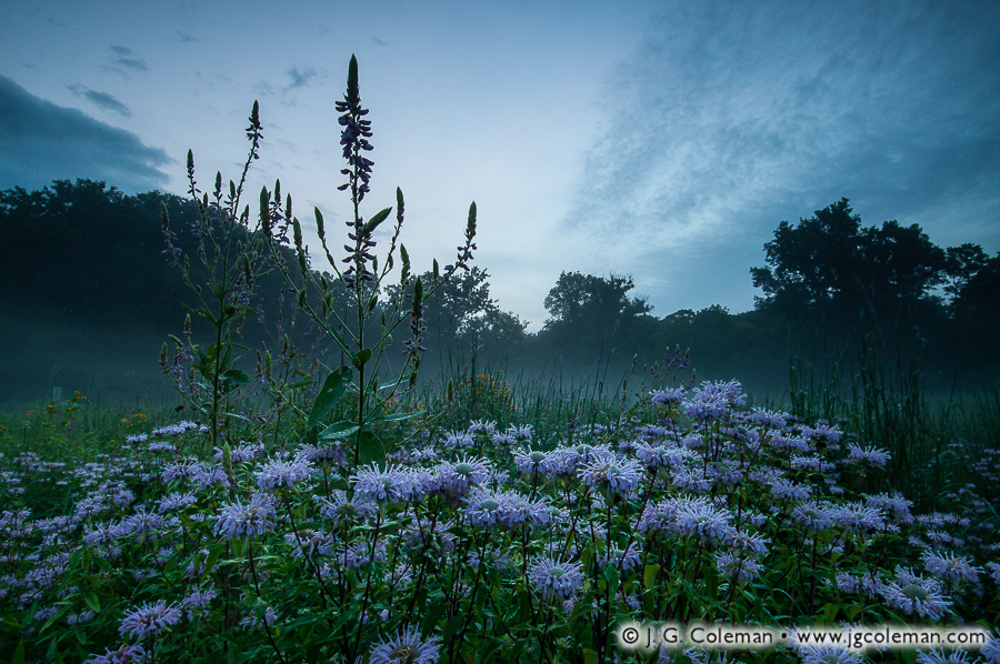
Heavenly Bantam
Little Pond, White Memorial Conservation Center, Litchfield, Connecticut

Even though the weather report called for partly cloudy conditions on this humid morning, there was mostly just vacuous, open expanses of sky over these lush wetlands in Connecticut’s Northwest Hills. It wasn’t until I was on the boardwalk heading back to the trailhead that I paused momentarily to take a look at some of the large cattail leaves nearby. Glancing beyond the leaves, I noticed an opportunity to capture the searing glow of the morning sun through a lingering mist which still swirled about landscape.White Memorial Conservation Center, Litchfield, CT


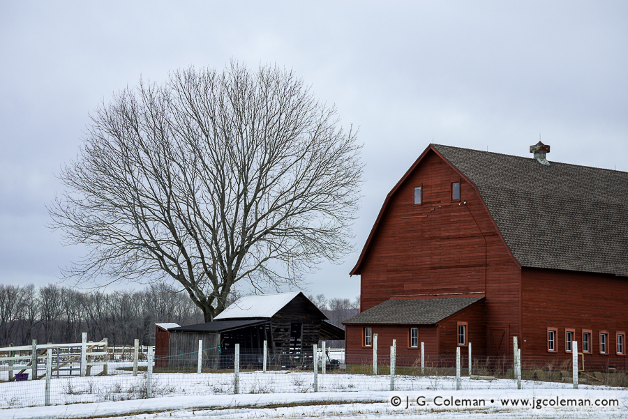
Yankee Farmlands № 9
East Granby, Connecticut

This time-worn barn along a rural stretch of road in East Granby had caught my eye weeks before I produced this image. I drove by it on several different occasions as we transitioned into October, waiting for just the right conditions which would conjure the nostalgic feel of a New England autumn. While the barn may be what folks tend to notice first, its stately, half-bare companion tree is really just as much the subject of this image.
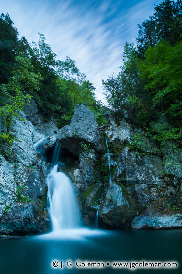
Barn in East Granby, Connecticut


Legend of Bash Bish
Bash Bish Falls State Park, Mount Washington, Massachusetts

Throughout 2014 I finally began to sincerely delve into the realm of black & white photography. The famous Bash Bish Falls of Massachusetts’ Berkshires was among the first subjects that I tackled and my interest with this image nudged me to keep at it the rest of the year, even if only infrequently.

Bash Bish Falls, Massachusetts


Bee Brook Autumn
Hidden Valley Preserve, Washington, Connecticut

By early October, most of Connecticut was still a few weeks from reaching peak autumn color, but the forests of Washington were already ablaze when I visited Bee Brook on a cool, overcast morning. Under spring or summertime conditions, this perspective is somewhat unremarkable, yet it takes on an entirely different character when every square foot of the forest floor is jacketed with a vivid mosaic of fallen leaves.

Bee Brook, Washington, Connecticut


Yankee Farmlands № 4
Bethlehem, Connecticut

When I happened upon this horse pasture just minutes after dawn, I knew I had quite a find on my hands. Horses stood quietly upon the hills, seeming almost contemplative amidst the hazy, humid atmosphere. Rendering a sunstar upon the back of the nearest horse was tricky, but I think it worked to introduce a stronger, more dramatic focal point in the composition.

Horse Pasture, Bethlehem, Connecticut


Awosting from the Heavens
Awosting Falls, Minnewaska State Park, Ulster County, New York

Several of the waterfalls in New York’s Catskills and Shawangunks feature impressive freefalls into broad, amphitheater-like gorges and Awosting Falls is no exception. For this shot, I used very deliberate framing and the perspective distortion of an ultra-wide-angle lens to create the illusion that the waterfall was dropping clean out of the sky into a dark pool amidst angular boulders and woodlands. In reality, it was plunging into the gorge from a ledge about 60 feet above my head.

Awosting Falls, Minnewaska State Park, Ulster County, New York


Black Rock Crescendo
Black Rock Harbor Light, Seaside Park, Bridgeport, Connecticut

The Black Rock Lighthouse is a welcome anachronism that sits upon a small island just off the coast of Bridgeport, one of Connecticut’s largest and busiest cities. When you walk to the island via a 1,000-foot breakwater and stand beside the tower as the sun rises over Long Island Sound, it’s surprisingly easy to forget about the warehouses and smokestacks which crowd the shores of the nearby mainland. I shot this photograph on the last day of winter in 2014 and the sunrise was so astonishingly beautiful —and yielded so many striking images— that I had quite a bit of difficulty selecting a “favorite”.

Black Rock Lighthouse on Black Rock Harbor, Seaside Park, Bridgeport, CT


As Yet Untitled
Broad Brook Reservoir, Cheshire, Connecticut

I spent the later half of my childhood just minutes from Broad Brook Reservoir, so its wooded shores and placid waters are inextricably linked to my memories from those early days. There’s just something about this lake which I find deeply comforting, so I felt especially privileged to be there during a positively glorious autumn morning in October just as strong, sharply-angled sunlight illuminated the lakeside forest.

Broad Brook Reservoir, Cheshire, Connecticut


Bull’s Crossing at Kent
Bull’s Bridge, Kent, Connecticut

For a good deal of 2013, I had been working on my Old Timbered Crossings project in which I sought to capture the distinctive character of each of the three 19th-century covered bridges remaining in Connecticut. Despite a handful of visits to this iconic bridge spanning the Housatonic River in Kent, it was the only one of the lot that I hadn’t checked off the list before the end of that year. When I lamented to a friend that none of my previous shots quite fulfilled my vision, he suggested trying to shoot the bridge from the opposite side. That simple recommendation held the key I’d been searching for and I managed to produce this photograph just about a week later on a frigid morning in late January 2014.
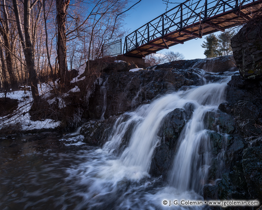
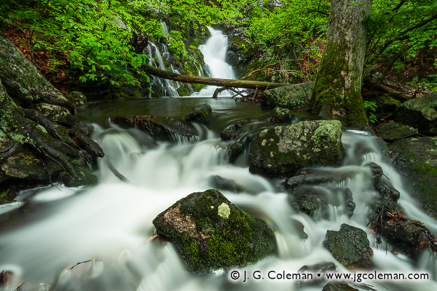
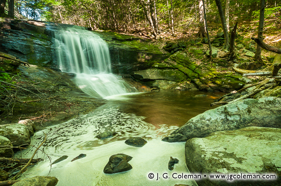
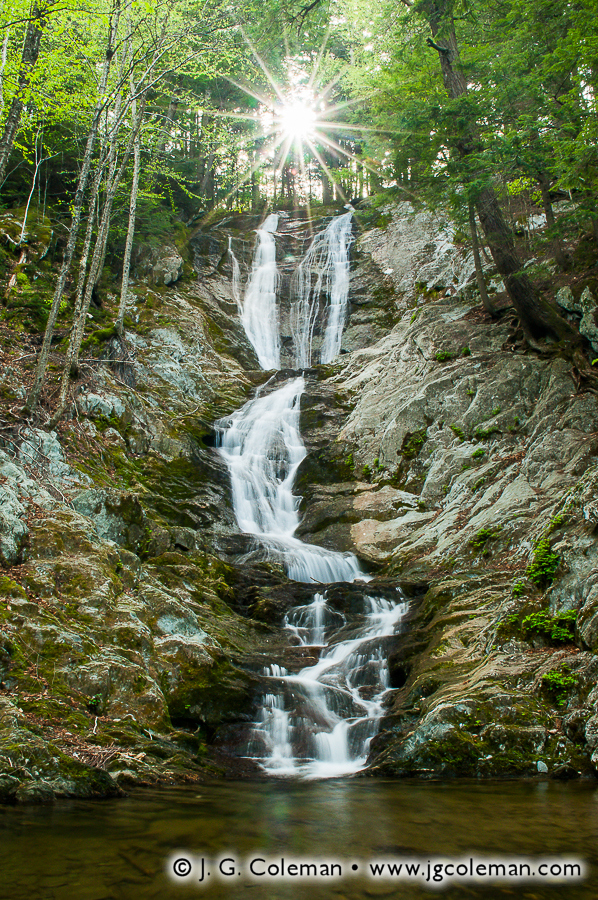
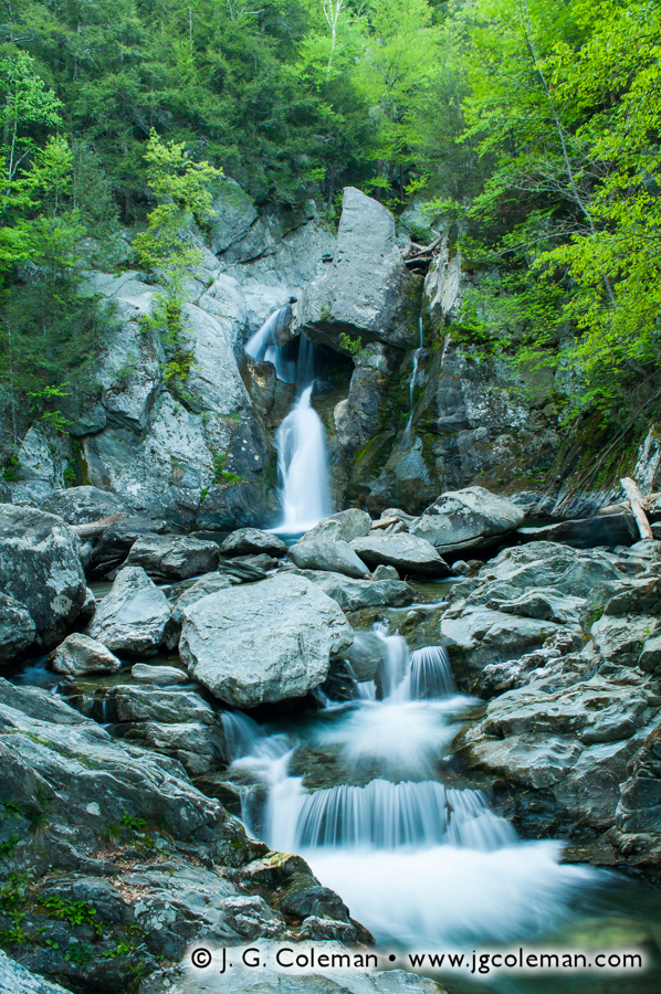
Bull's Bridge over the Housatonic River, Kent, Connecticut


Carpenter’s Summer
Carpenter’s Falls, McLean Game Refuge, Granby, Connecticut

Carpenter’s Falls, a small waterfall in the expansive McLean Game Refuge, was somewhat starved for water when I arrived in late June. I was half expecting this, since waterfalls that are raging with spring rains and snow melt generally tend to grow more and more tame as the months progress, bringing hotter temperatures and reduced rainfall. Sometimes this reduced water volume can sap a waterfall of its aesthetic impact, but Carpenter’s Falls managed to retain its lively character even as a singular braid of wispy whitewater amidst moss and woodland grasses.
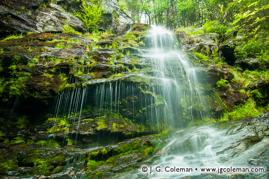
Carpenter Falls, McLean Game Refuge, Granby, Connecticut


As Yet Untitled
Chapman Falls, Devil’s Hopyard State Park, East Haddam, Connecticut

Chapman Falls is one of Connecticut’s more prominent waterfalls. It is the aesthetic centerpiece of Devil’s Hopyard State Park and probably draws more visitors than any of the 1,000 acres of forest that surround it. As such, it tends to be photographed very often and it’s difficult to create a photograph there which makes an original statement. So, rather than shooting a head-on “portrait” of Chapman Falls, I instead mounted my camera on the tripod just inches from the water and let the swirling foam at the base of the falls do most of the talking.

Chapman Falls, Devil's Hopyard State Park, East Haddam, CT


Autumn at the Stone Church
Dover Stone Church, Dover, New York

The Dover Stone Church is one of those natural landmarks that was once quite celebrated during the Victorian Era, but which more or less fell off the map as long-distance automobile travel began to extinguish the novel excitement behind so many local curiosities in the American Northeast. Although it looks to be a deep cavern plunging into the earth, the Stone Church is actually more akin to a small slot canyon. Over thousands of years, the brook I’ve portrayed in the foreground managed to eroded its way down through a massive rock outcropping, eventually chiseling out an impressive, 30-foot-tall hollow in solid stone.

Dover Stone Church, Dover, New York


Yankee Farmlands № 12
Avon, Connecticut

The first snowfall of winter this year blanketed the stubble of harvested cornstalks at this farm on the borderlands between Avon and Farmington. This freshly-frosted landscape was positively beautiful, but it was the particularly the bare, sprawling crown of this lone tree amidst the fields that really caught my eye. Composing the shot such that the sun blazed through the silhouetted branches was my way of drawing the viewer’s eyes into the heart of the scene.

Farmland in Avon, Connecticut


Yankee Farmlands № 16
Durham, Connecticut

The transitional period between autumn and winter is, for me at least, the most challenging time of year to pursue landscape photography in New England. It’s late enough that the trees have grown bare and colorless, yet oftentimes still too early for a persistent snowpack. The result is a decidedly bleak landscape which sometimes leaves me feeling a bit uninspired. Nonetheless, I still hit the road and roll the proverbial dice in search of rare opportunities. My efforts paid off this time around when I discovered a gated pasture overlooking a wooded hill painted liberally with the warm light of dawn.
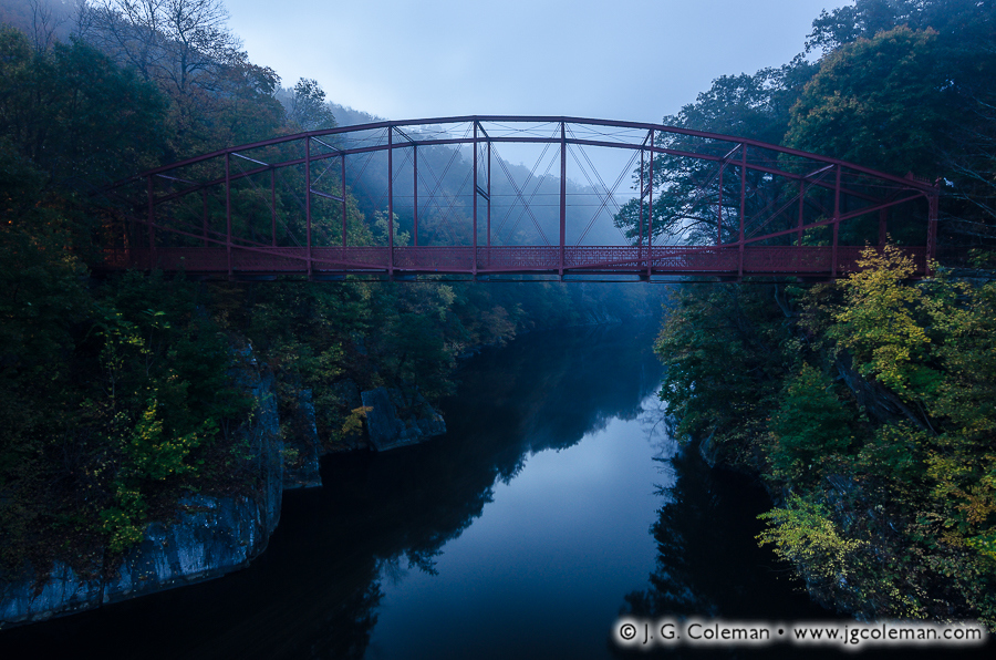
Pasture in Durham, Connecticut


As Yet Untitled
Bridgewater, Connecticut

Lover’s Leap State Park in Bridgewater offers a spectacular cliffside overlook with panoramic views of Lake Lillinonah, a scenic reservoir on the Housatonic River. I was sure that a blanket of fog rolling over the landscape would make for an epic sunrise photograph from the overlook on this particular morning. Instead, it thickened to the point that I couldn’t see anything more than 100 feet away, much less the sprawling lake below. Thankfully, my favorite image of the day was taken in the dark twilight before I had even made my way to the overlook! The fog was still relatively thin this early in the morning, offering the opportunity to capture a positively ethereal image of this antique iron bridge spanning the shadowy gorge of the Housatonic just upstream of the reservoir.
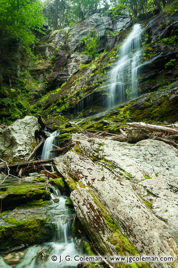
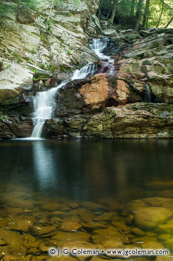
Iron Bridge Spanning the Housatonic River, Lover's Leap State Park, Bridgewater, Connecticut


Kaaterskill Shadows
Kaaterskill Falls, Kaaterskill Wild Forest, Hunter, New York

I had done several hours of online research and looked at dozens of images before setting out into New York’s Catskills to photograph Kaaterskill Falls, but seeing this majestic waterfall in-person still proved to be a genuinely memorable experience. Certainly one of the grandest waterfalls in the American Northeast, Kaaterskill Falls plunges some 260 feet over two impressive drops through a cavernous gorge crowded by woodlands. This black & white photograph was certainly among my favorites from that trip, featuring the upper tier of Kaaterskill as it freefalls 170 feet over a precipitous cliff into a shallow pool below.

Kaaterskill Falls, Kaaterskill Wild Forest, Hunter, New York


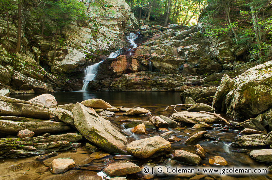
Last Throes of Winter
Kent Falls State Park, Kent, Connecticut

Kent Falls is one of those places that has, as I oftentimes put it, generally been “shot to death” by Connecticut nature photographers. What I mean is simply that the obvious, scenic viewpoints along the falls have been photographed so many times that it’s extremely challenging to go there and produce images that offer some measure of uniqueness. I had that very thought in mind on a frigid morning in April after a springtime squall dumped a few inches of snow on Connecticut’s Northwest Hills. Instead of shooting for the larger waterfalls, I decided emphasize the more subtle characteristics of the cascades, the striated bedrock of the riverbed and the freshly-frosted forest.

Kent Falls, Kent, Connecticut


Winter’s Kiss
Black Pond SWMA, Middlefield, Connecticut

Between the subtle lighting and the delicate frost, this jumble of fallen oak leaves offers me more than just a visual impression… I can feel the chill in the air and hear the brittle, icy leaf litter crunching underfoot as I walk along. When I arrived at Black Pond on this cold morning just about a week before the winter solstice, I had every intention of leaving with a landscape photograph. Suitable conditions just didn’t materialize, but that proved to be a stroke of luck, since I might otherwise have carelessly stepped right over this miniature leafscape.

Leaves ay Black Pond, Middlefield, Connecticut


True Niagara
Niagara Falls, Canada

When I initially attempted to photograph Niagara Falls from the west corner of the Canadian horseshoe in early April, I was confronted by an absolutely frigid mist blasting so forcefully out of the gorge that I could scarcely finish a single exposure before my lens was glistening with water and required cleaning. Shooting conditions like that simply weren’t going to work, so I was faced with trying to find an alternative. As it happens, I did ultimately figure out how to shoot these falls without soaking my camera and this photograph, in which I tightly framed the falls, mist and upstream rapids, proved to be my favorite image of the trip. How did I do it? Well, I shot it through a window more than 30 stories in the air during morning twilight… all from the warmth and privacy of my hotel room. Sometimes, it’s best to improvise!

Horseshoe Falls, Niagara Falls, Canada


Dominion of the Gulls
Pleasure Beach, Bridgeport, Connecticut

Anyone not well-versed in the fairly obscure story of Pleasure Beach may wonder how so many seashells could find their way on top of a bridge. Interestingly, they were all deposited there by seagulls which cleverly break open snails and clams by dropping them upon the rigid bridge decking from a few dozen feet in the air. Because Pleasure Beach has been abandoned for nearly two decades, there was more than enough time for the fragmented shells to accumulate. (Side note: After several years of abandonment, Pleasure Beach was officially reopened as a city park in 2014, just a month or so after I took this photograph.)

Pleasure Beach, Bridgeport, Connecticut


As Yet Untitled
Sleeping Giant State Park, Hamden, Connecticut

One thing is for sure: man-made structures were more prominent in my photography throughout 2014 than they had been for all of the prior years combined. My Old Timbered Crossings project, for example, featured covered bridges and my on-going Yankee Farmlands project oftentimes incorporates barns, silos and fences. In this case, my subject was the ruins of a long-abandoned quarry facility in Sleeping Giant State Park. The old quarry operation blasted traprock from one of the adjacent Sleeping Giant mountains until 1933 when determined conservationists thankfully purchased and preserved the land.

Quarry Ruin at Sleeping Giant State Park, Hamden, Connecticut


Saugatuck Whitewater
Saugatuck Falls Natural Area, Redding, Connecticut

By mid to late summer, the Saugatuck River in Redding assumes a fairly tame demeanor as it loses water volume to dwindling rains and hotter temperatures. Head there in May like I did, though, and you’re likely to find the banks inundated and the waters angrily peeling through boulder-laden rapids just below Saugatuck Falls. The powerful impression of rugged remoteness contained in this photograph is one reason why it’s among my favorites of 2014. Looks can be a bit deceiving, though: if I were to walk just 200 feet west from this scene through woods, I would find myself on the shoulder of Route 53.

Saugatuck Falls, Saugatuck Falls Natural Area, Redding, Connecticut


As Yet Untitled
Scovill Reservoir, Wolcott, Connecticut

Scovill Reservoir is near and dear to me… and when I say it’s near, I mean that I can drive there in a few seconds. Not only is it my bass fishing hole, but it’s also a fairly picturesque lake in its own right. The advantage to living right beside this wooded pond is that I constantly have the opportunity to make the most of interesting conditions, experimenting with new perspectives or re-interpreting the view from my favorite spots. This photograph of a small cove is my top pick for Scovill Reservoir in 2014 because I was able to bring together so many elements: the dramatic clouds of dawn, the densely wooded shores, the lush vegetation thriving at the water’s edge and fallen pine needles collecting in the shallows.

Scovill Reservoir, Wolcott, Connecticut


Yankee Farmlands № 7
East Windsor, Connecticut

This past summer, I began working on my Tobacco Valley project in which I seek to document the rhythms, sights, and textures of tobacco agriculture in the Connecticut River Valley. I’m very excited about this project, but I’ve mostly kept my work on it under wraps until I can complete a year’s worth of shooting and really capture the character of these unique Connecticut farmlands throughout every season. I’ll make an exception for this retrospective, though: this photograph of a shade tobacco farm in East Windsor was certainly among my favorites for 2014 (you can see one more piece from my Tobacco Valley project in this retrospective, also; I just couldn’t help myself!). If you’re interested in seeing the full range of work included in my Tobacco Valley project, rest assured that I’m still out there actively shooting. Keep your eyes peeled in the later half of 2015!

Shade Tobacco Farm, East Windsor, Connecticut


Shepaug Rejoicing
Washington, Connecticut

When I captured this photograph of a glorious shaft of light pouring over the forest into the Shepaug River gorge in Washington, I couldn’t possibly have known that my camera would vanish without a trace just a week later. Indeed, one of the low points of 2014 was undoubtedly waking up in early autumn to find that almost all of my gear had been stolen from my truck… right in my own driveway no less! That was a pretty demoralizing blow which came in the middle of one of New England’s most photogenic times of year. Insurance came through, of course, and I was back up and running by early November… but by that time, the forests were more or less stripped bare.

Shepaug River, Hidden Valley Preserve, Washington, Connecticut


Yankee Farmlands № 5
Simsbury, Connecticut

This is probably one of the more subtle photographs that made it into my Favorite 30 of 2014. Driving along on a quiet road in Simsbury, I discovered this cluster of large, round hay bales nestled beside a small stand of woodlands just days after they’d been collected from an adjacent hayfield. There’s no eye-melting sunrise here, no majestic waterfall, no dreamy fog; just the quietude at the edge of the farm and a beautiful interplay between light and shadow that just sort of grasps my sensibilities for one reason or another.

Hay Bales in Simsbury, Connecticut


As Yet Untitled
Talcott Mountain State Park, Simsbury, Connecticut

Rising nearly 1,000 feet over the surrounding landscape in Simsbury, Talcott Mountain is certainly one of the more prominent traprock ridges of the Metacomet Range. Perched atop the high cliffs is the 165-foot tall Hublein Tower, imparting a unique element to the profile of this otherwise gently-sloping, wooded ridge. I’ve photographed Talcott Mountain several times during every season, but I don’t think I’ve ever seen it looking quite as beautiful as it did on this day in early October as the setting sun cast a warm glow upon the landscape and threw long shadows across the cornfields. I hadn’t even intended on stopping when I drove by, but within moments of passing this vista I knew I had to turn around and get the tripod set up as quickly as possible.

Talcott Mountain, Simsbury, Connecticut


As Yet Untitled
Simsbury, Connecticut

In the 1920s and 1930s, roughly 15,000 acres of farmland in Northern Connecticut was dedicated to the cultivation of tobacco. Although some of the world’s finest tobacco still comes from that region, the market has atrophied in the past century and most of the old farms have been supplanted by corporate office buildings, suburbs and woodlands. Drive around enough on the backroads, though, and you’ll occasionally stumble upon decades-old abandoned barns that were once used to dry the freshly-harvested crops. I captured this image inside one of those old barns as bright, mid-day sunlight pierced the weathered siding.
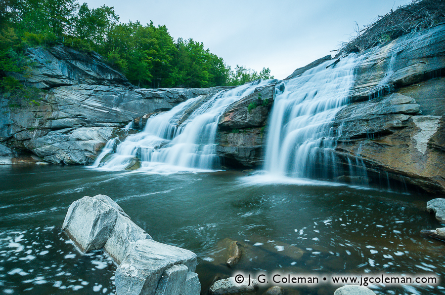
Interior of Abandoned Tobacco Shed, Simsbury, Connecticut


The Wild Coginchaug
Simsbury, Connecticut

If you found me out on the Coginchaug River on this drizzly, overcast day in late April, chances are pretty good that I would’ve been donning my waders, fishing vest and trout rod; fishing was really all I had in mind at the time. After hooking into a few, I set my attention to Wadsworth Falls and noticed that the roaring whitewater was churning up patches of foam that drifted quite far downstream before dissipating. I suddenly envisioned an image and returned to my truck, swapping my fishing pole for my camera gear. This was the photograph which was born out of that chance visualization.

Wadsworth Falls, Middlefield, Connecticut


As Yet Untitled
Westbrook, Connecticut

Taken in the context of Connecticut’s 100 miles of coastline, West Beach is just a little-known, 1/2-mile sandy beach in the small, little-known town of Westbrook. I suppose that the ordinary person might consider it to be a fairly unremarkable stretch of shoreline. And yet, having grown up there each summer as a child, I cannot possibly overstate the immense role that this beloved beach has played in my life. Years of exploring the sandbars, offshore islands and saltwater wildlife has indelibly etched this seascape into my psyche… perhaps even helped to shape me into the person I am today. I take several dozen photographs of West Beach every year and this past year was no exception, though this piece was easily my favorite of 2014.

West Beach, Westbrook, Connecticut


Looking Ahead to a Promising 2015

There you have it… my favorite 30 photographs of 2014. Again, many strong photographs just couldn’t be fit edgewise into this limited-length line-up, so be sure to check out the broad range of work that I released over 2014 at my online galleries. Also, be sure to follow my work on the social network of your choice: Facebook, Flickr, Google Plus, Instagram… I’ve got em all.

But most importantly, I hope you look forward to a promising 2015 and embrace the opportunities and fortunes that come your way, while weathering with resolve the difficulties that may lie between. I leave you now with the words of Henry Ward Beecher:

“Every man should be born again on the first day of January. Start with a fresh page. Take up one hole more in the buckle if necessary, or let down one, according to circumstances; but on the first of January let every man gird himself once more, with his face to the front, and take no interest in the things that were and are past.”

-Henry Ward Beecher (1887)

As part of J. G. Coleman’s Decor Series prints, many of the works seen here are available at Fine Art America. You are encouraged to visit J. G. Coleman’s Fine Art America eStore, or see all of Fine Art America’s nature art.

Categories
New Print Releases The American Northeast

Falls of the Mianus Gorge

Havemeyer Fallscape (Havemeyer Falls, Mianus River Gorge Preserve, Bedford, New York)
“Havemeyer Fallscape”
Havemeyer Falls on Havemeyer Brook,
Mianus River Gorge Preserve, Bedford, New York
© 2014 J. G. Coleman

In 1955, its protection became the goal of the very first land project undertaken by The Nature Conservancy. By 1968, it was the first location in the United States to be federally-recognized as a National Natural Landmark by the National Park Service. It is home to towering hemlocks so ancient that they were already a century old when the American Revolution came to a close. But if all of these facts about the Mianus River Gorge Preserve are surprising, perhaps the most unbelievable part is that this 760-acre nature preserve is sprawled out across a handful of suburban towns just 30 miles from the streets of New York City!

My latest work from this unique preserve showcases some of the superb scenery which is characteristic of the wildlands of the American Northeast. In my piece, “Havemeyer Fallscape” (at top), the pristine waters of Havemeyer Brook leap eagerly over a forest-crowded ledge, dodging downed trees and boulders en route to a confluence with the Mianus River.

Winding Like the River (Mianus River Gorge Preserve, Bedford, New York)
“Winding Like the River”
Mianus River Gorge Preserve, Bedford, New York
© 2014 J. G. Coleman

Among my newer works from this preserve is also “Winding Like the River” (above), which portrays one of the time-worn hiking trails that weaves through the shadowy woodlands just uphill of the Mianus River Gorge. As I walked upon this particular stretch of trail, I realized that slipped through the forest in broad, serpentine bends with much the same grace as the Mianus River itself weaved its own course at the bottom of the gorge nearby.

Want to See More?

Categories
All Things Connecticut New Print Releases The American Northeast

Autumn Meditations

Housatonic Reverie (Housatonic River, Cornwall, Connecticut)
“Housatonic Reverie”
Housatonic River, Cornwall, Connecticut
© 2013 J. G. Coleman

That narrow interval during Autumn, when the forests transition to a collage of saturated colors, is always a magical time in the American Northeast. It’s a fleeting crescendo in which we bid farewell to the warmth and past experiences of spring and summer, enjoying one last, vivid hurrah before being plunged into the frigid months that will see us into a new year. Autumn resonates deeply within the collective psyche of New England. But now that winter is upon us, already blanketing the Connecticut landscape in a few successive layers of snow and ice, I’d like to bring us back just a couple months to the warm colors and soothing temperatures of Autumn 2013.

Housatonic River in Connecticut’s Northwest Hills
Cornwall & Sharon, Connecticut

In my new piece, Housatonic Reverie (above), we find ourselves peering out over cold rapids on the Housatonic River in Cornwall, Connecticut. As we follow the undulating waters deeper into the landscape, we are surrounded by woodlands still cloaked in the shadows of twilight. But with fresh morning sun being cast from the east through a veil of mist, a gently-sloping hill on the horizon is set ablaze, becoming a glowing beacon of autumn color in a landscape that is still waking up to a chilly October morning.

Housatonic Reverie is just one of several pieces that I managed to produce as this truly glorious morning on the Housatonic Valley unfolded before my eyes. But if there’s one view of a landscape that I almost never capture, it’s a view which includes me! After all, I’m alone for most of my shoots and I’m generally busy behind the camera. But on this particular morning, I was out shooting with long-time friend and photographer, Ryan Dolan. While I was down on the boulder piles beside the river producing Housatonic Reverie, Ryan managed to frame me up in a unique exposure on black and white film (below).

Housatonic River (Photograph by Ryan Dolan)
Using black & white film, photographer Ryan Dolan captured this photograph of me on the
Housatonic River just minutes after I shot “Housatonic Reverie” (photo at top)
© 2013 Ryan Dolan

His resulting image, which actually appears to have been taken perhaps five or ten minutes after I shot Housatonic Reverie, possesses a fascinating aesthetic that is a world apart from that of my own piece. What I found especially intriguing about his photograph was the timelessness that it so effortlessly conveys. Although we may know that it’s me on those rocks and that this image was taken only a few months ago, when we explore the world that Ryan has framed up here, we find almost nothing that tethers it to modern times. There’s the sense that this image could just as well have emerged from a century-old chest in some dusty farmhouse attic… that the photographer down there on the Housatonic is some anonymous soul of the 1800s that has long since been swallowed up by time and all but lost to history. There’s surely a vein of potent nostalgia in this emotive image, but this piece barely scratches the surface of Ryan’s work. I encourage you to explore more of his photography at ryandolanart.com.

My next piece brings us just a few miles south to Sharon, Connecticut, where the wide, shallow breadth of the Housatonic River snakes peacefully through a deeply-furrowed valley. At every turn the river is flanked by picturesque wooded hills, each one with a distinctive profile wrought in radiused slopes.

Twilight on Housatonic Meadows (Housatonic River, Sharon, Connecticut)
“Twilight on Housatonic Meadows”
Housatonic River, Housatonic Meadows State Park, Sharon, Connecticut
© 2013 J. G. Coleman

Shadowy blue tones, swirling mist and the leafless crown of an overhanging tree conspire to produce a mournful aesthetic in my piece, Twilight on Housatonic Meadows. The conditions on the Housatonic that morning were touch-and-go from a photographer’s perspective, for while the drifting blankets of fog lent a powerfully ethereal quality to the landscape, they also threatened to blot out key elements of the vista. I managed to take Twilight on Housatonic Meadows during a fleeting minute when the dense atmosphere thinned out just enough to reveal sparse wispy clouds and the contour of a distant hill.

Connecticut’s Waterfalls Amidst Falling Leaves
Cheshire, Franklin & Simsbury, Connecticut

Roaring Brook Autumnlands (Roaring Brook Falls, Cheshire, Connecticut)
“Roaring Brook Autumnlands”
Roaring Brook Falls, Cheshire, Connecticut
© 2013 J. G. Coleman

Recently, I released a brand new fine art photography collection titled “Waterfalls of Connecticut“, the culmination of some four years of waterfall photography throughout Connecticut (if you haven’t seen it yet, be sure to check it out). Included in the collection are a few pieces that I managed to produce over this past Autumn, but which were still so new that they hadn’t even been released on my online galleries until now! I’ve finally rolled them out at JGCOLEMAN.COM and here we’ll explore these new works and take a look at how Fall 2013 produced some great conditions for waterfall photography.

Roaring Brook Autumnlands (at right) exemplifies the vivid color palette that we associate with autumn in New England. In this piece, we follow the waters of Roaring Brook Falls as they careen dozens of feet down a cliffside in the woodlands of Cheshire, Connecticut. At the precipice of the falls, we are treated to a cornucopia of saturated colors, from the glowing shades of orange in the forest canopy to the bold blue sky overhead. In truth, it can be extremely difficult to pull colors this “pure” out of any Autumn scene. The critical element in Roaring Brook Autumnlands —the condition that really brought this shot to life— was the magnificent, early-morning sun, which cast warm light upon the forest at the brink of the falls while leaving the cliff-face below painted in shadow. The contrast between dark, glistening rock and fiery, luminous woodlands really breathes life into this vista and reminds us of just how awe-inspiring our landscapes can be during those fleeting months of autumn.

Falls Along the Gap (Ayer's Gap Falls, Ayer's Gap Preserve, Franklin, Connecticut)
“Falls Along the Gap”
Ayer’s Gap Falls, Ayer’s Gap Preserve,
Franklin, Connecticut
© 2013 J. G. Coleman

My next piece, titled Falls Along the Gap (at right), brings us 40 miles east to Franklin, Connecticut, where gentle wisps of Bailey Brook plunge over rocky outcrops layered with a collage of fallen leaves. Connecticut was particularly dry during much of the Autumn season, a condition which can oftentimes leave smaller waterfalls throughout the state nearly dry. In the case of Falls Along the Gap, however, the reduced water volume on Ayer’s Gap Falls was the crucial ingredient which allowed thousands of autumn leaves to accumulate in areas that might otherwise have been scraped bare by swift currents.

Within At the Northgate (below), my new piece from Northgate Falls in Simsbury, Connecticut, fallen leaves have completely blanketed the forest floor, dramatically framing off the reflecting pool at the base of the cascades. This piece captures a different side of the autumn aesthetic: that wistful atmosphere in which the last throws of autumn feel more like a beautiful, bittersweet farewell rather than an eager stride into the coming months of snow and ice.

Here again, the dry months of summer and early autumn had left this branch of Bissell Brook with greatly reduced water volume. Northgate Falls is not a particularly large waterfall to begin with, but it was rendered especially tranquil at this point in late October.

At the Northgate
“At the Northgate”
Northgate Falls, near McLean Game Refuge, Simsbury, Connecticut
© 2013 J. G. Coleman

Wind Gate at the Hudson Highlands
Cornwall, New York

Of course, New England isn’t the only place that offers stunning scenery during Autumn. My next piece brings us 20 miles east of the Connecticut state line to a celebrated place in the history of landscape art: New York’s Hudson River Valley.

Storm King Mountainscape (Storm King State Park, Cornwall, New York)
“Storm King Mountainscape”
Storm King Mountain on the Hudson River,
Storm King State Park, Cornwall, New York
© 2013 J. G. Coleman

In my piece, Storm King Mountainscape (above), we peer out over the wide expanse of the Hudson River beneath a dawn sky awash with color. The facing slope of Storm King Mountain, a prominent, dome-shaped peak that abruptly rises more than 1,300 feet over the river below, glows with with molten color as the earliest sunlight of the morning carves blazing gashes into the shadowy bluffs.

Although Storm King Mountain is the star of this new piece, the photograph was actually taken from the opposite side of the river on a rocky promontory of Breakneck Ridge. Breakneck and Storm King are the distinctive sentinels that form the “Wind Gate”, the mountainous northern entrance into the Hudson Highlands region of New York. While it was early Dutch settlers that coined that term (originally “Wey Gat”), it was the painters of the famous Hudson River School that took to channeling the sublime qualities of this place into profound works of fine art. Throughout the 1800s, Storm King Mountain and Breakneck Ridge were featured in exquisite paintings by Thomas Cole, Samuel Colman, Thomas Benjamin Pope, Regis Frances Gignoux, Homer Dodge Martin and Jasper Cropsey, to name only a few.

A Farewell to Autumn
Wolcott, Connecticut

I’d like to leave you with a piece that portrays barely a foot of the forest floor from edge to edge, but which manages to say just as much about autumn as the vast panorama from Breakneck Ridge or the wide vistas of the Housatonic.

Sugar Maple Castaway (Finch Brook Preserve, Wolcott, Connecticut)
“Sugar Maple Castaway”
Finch Brook Preserve, Wolcott, Connecticut
© 2013 J. G. Coleman

Produced barely ten minutes from my home in Wolcott, Connecticut, my piece Sugar Maple Castaway is a simple, but potent, expression of the beauty of autumn. Da Vinci once wrote that “simplicity is the ultimate sophistication”, and when we draw our attention to just a single lonely leaf beaming with color upon the forest floor… well, there’s no doubt that the old master was on to something.

As part of J. G. Coleman’s Decor Series prints, many of the works seen here are available at Fine Art America. You are encouraged to visit J. G. Coleman’s Fine Art America eStore, or see all of Fine Art America’s new england art or autumn art.

Categories
New Print Releases The American Northeast

Journey Into the Berkshires (pt. 3)

Falls on Mount Everett (Race Brook Falls, Mount Everett State Reservation, Sheffield, MA)
“Falls on Mount Everett”
Race Brook Falls, Mount Everett State Reservation, Sheffield, Massachusetts
© 2013 J. G. Coleman

“When we try to pick out anything by itself,” wrote renowned naturalist, John Muir,” we find it hitched to everything else in the Universe.” Such is the case with that territory we call The Berkshires. From the standpoint of geology, determining where the Berkshires begin and end is actually a bit more complicated than determining which county of Massachusetts they are named after. Take Mount Greylock, for instance, which has always been popularly thought of as the grandest mountain of the Berkshires. In reality, it’s part of the neighboring Taconics, a separate mountain range to the west of The Berkshires which occasionally spills over into Berkshire County. But even the true Berkshires are actually a vast southern stretch of the Green Mountains that we usually associate with Vermont.

So, for the third and final installment of Journey Into the Berkshires, we’re going to do something a bit different: journey out of the Berkshires, ending our travels at some of the landscapes that lie in the periphery of these iconic mountains of Massachusetts.

Race Brook Falls
Sheffield, Massachusetts

In the woodlands of Sheffield, only a few miles north of the Connecticut state line, Race Brook courses through the heart of the 1,300-acre Mount Everett State Reservation. The stream tumbles feverishly down from the heights of the Reservation’s namesake mountain, draining the forests that flank its southern slope. Unlike nearby Bash Bish Brook, Race Brook doesn’t seem to have a place in the legends of the Berkshires; there aren’t any ancient tales of romance or tragedy to be found in the books, even if that’s only because time has swallowed them up. But what Race Brook may lack in provenance, it more than makes up for with striking scenery.

Race Brook Marble (Race Brook Falls, Mount Everett State Reservation, Sheffield, Massachusetts)
“Race Brook Marble”
Race Brook Falls, Mount Everett State Reservation, Sheffield, Massachusetts
© 2013 J. G. Coleman

Take my new piece, Falls of Mount Everett (at top), in which Race Brook leaps frantically from a precipice, churning to whitewater before crashing into the bedrock below. Patches of vibrant moss mottle the surface of surrounding bedrock, generously nourished by a stray portion of the brook that escapes the falls, instead trickling from the adjacent ledge in fine strands. This is only one of several cataracts to be found along Race Brook, for it is in this area that the stream descends nearly 1,000 feet down the steep slopes of the highlands before joining with Dry Brook in the valley below.

Mount Everett State Reservation is just one of several expanses of protected wildlands in the far-southwestern corner of Massachusetts. Just a few miles to the west is the 4,000-acre Mount Washington State Forest and the smaller, but much renowned, Bash Bish Falls State Park. Adjoining Mount Everett to the north, we find the 1,100-acre Jug End State Reservation. But even though there’s plenty to see here, we aren’t sticking around. Instead, we’re following the mountains south, departing Berkshire County and heading into the Nutmeg State.

Great Falls of the Housatonic
Canaan, Connecticut

The mountains and hills of Connecticut’s northwestern corner are oftentimes called “The Northwest Hills”, a name which could understandably be mistaken for a simple, literal description. Some folks are partial to the view that the Northwest Hills are just as much a part of The Berkshires as the mountains further north in Massachusetts. Indeed, there doesn’t seem to be any physical feature of the landscape that we could pinpoint as the clear place to delineate The Berkshires from the Northwest Hills; where does one draw the line? Even still, there are many that scoff at the notion that The Berkshires extend as far as 20 or 30 miles south into Connecticut, encompassing towns such as New Fairfield, Roxbury, Wolcott and Burlington. These are all hilly towns, for sure, but it’s difficult to equate their hilly terrain with an iconic mountain range that lies far away in the namesake county of a different state. And on that note, if The Berkshires are contained mostly in Berkshire County, Massachusetts, then shouldn’t the mountains in northwestern Connecticut’s Litchfield County be dubbed “The Litchfields”? Well, pretty close: the Northwest Hills are perhaps more romantically dubbed “The Litchfield Hills”.

Great Falls on the Housatonic (Great Falls on the Housatonic River, Canaan, Connecticut
“Great Falls on the Housatonic”
Great Falls, Canaan, Connecticut
© 2013 J. G. Coleman

Our jaunt into the Litchfield Hills brings us only about 5 miles south of the Massachusetts border into the town of Canaan, Connecticut. Encompassing 33 square miles with barely over 1,000 people, the rugged terrain and expansive, unpopulated wildlands of Canaan possess an aesthetic that is practically indistinguishable from that found up north in the Berkshires. Even the bedrock that underlies the landscapes of Canaan is part and parcel to the same vast veins of pale limestone and marble that we find exposed at Bash Bish Falls, Tannery Falls, Wahconah Falls, Race Brook and other rugged gorges throughout Western Massachusetts.

But there’s one major way in which Canaan’s Great Falls differs from those scenic waterfalls of the Berkshires: it’s much larger. Located in the Falls Village section of town, this impressive cataract sees the full, 100-foot breadth of the Housatonic River dumped 60 feet over a massive ledge of time-worn limestone. A 60foot drop is by no means unheard of among waterfalls of Southern New England, but most of those are formed along the course of modest woodland brooks, not sizable rivers like the Housatonic. During high-water episodes, more than 18,000 gallons of water crash angrily over Great Falls every second; no other waterfall in Southern New England is so voluminous. But when you take a look at my new piece, Great Falls on the Housatonic (above), you’ll find it portrayed during a time of much-reduced waterflow, the river streaming swiftly down marble cliffs beneath the dying light of dusk.

Only a few hundred feet upstream of Great Falls, the Falls Village Dam diverts a significant portion of the Housatonic’s volume for power generation. This leaves the waterfall starved for water during drier times of year. During snow melts and spring rains, though, the Housatonic swells far beyond the needs of the hydroplant and immense torrents bypass the dam and crash magnificently over Great Falls. So although seeing this waterfall in all of its crushing glory requires somewhat precise timing, Great Falls is nonetheless an impressive sight during just about any time of year.

Chapel Falls
Ashfield, Massachusetts

Our journey from the heart of the Berkshires to the borderlands of those famed mountains doesn’t end in Connecticut, though. Instead, we’re going to leave the foot of Great Falls and head northeast about 50 miles, back into the highlands of Massachusetts for a quick stop in the forests of Ashfield. It is here that Chapel Brook meanders through the gently sloping woodlands of Pony Mountain, keeping a mostly calm and reserved demeanor until spilling over a series of abrupt rock ledges to form Chapel Falls. My new piece, “On the Flank of Pony Mountain”, brings us into the Chapel Brook gorge where the waterfall plunges over a rock outcropping into the pool below. Foam churned up by the falls swirls along the periphery of the brook, ever cloaked as it is in the thick shadows of the forest canopy despite the rather sunny, cloudless day overhead.

On the Flank of Pony Mountain (Chapel Falls, Chapel Brook Reservation, Ashfield, MA)
“On the Flank of Pony Mountain”
Chapel Brook Reservation, Ashfield, Massachusetts
© 2013 J. G. Coleman

Protected as part of Chapel Brook Reservation, Chapel Falls lies within Franklin County, some 10 miles east of the Berkshire County line. But even if it doesn’t fall within the political boundaries of Berkshire, Chapel Falls and the vast 40-square-mile expanse of Ashfield are typically described as laying within the eastern foothills of the Berkshires. Of course, merely experiencing the furrowed and densely forested terrain of this region is indication enough that it has inherited more than a bit of the character of the mountainlands to the west.

Until Next Time…

With that, we conclude our Journey Into the Berkshires, even if there’s still plenty more to see in these scenic mountainscapes of Western Massachusetts. Looking back at the three-part series of new prints, though, there’s little doubt that plenty of ground has been covered. We’ve traveled to the northern Berkshires to peer out from the heights of Mount Greylock, marveled at a sun halo from the grounds of Natural Bridge and stood at the foot of Tannery Falls. In the central Berkshires, we delved deep into the legend of Wahconah Falls. Bash Bish Falls and Race Brook Falls were welcome stops in the southern Berkshires. We’ve even managed to push into the neighboring highlands to take in the views at Chapel Brook and headed down the Housatonic River to see the Great Falls in Connecticut’s northwest.

“There is something about the scenery,” wrote Clark Bryan in his 1887 Book of Berkshire,” that imparts a quietude, a repose, a freedom from distraction, a healing with the balm of Dame Nature. The unequaled harmony of the surroundings exhales an influence that enraptures the beholder, and creates within him an inward form of the external.” Bryan’s time has long since past, just as the way of life in the Berkshires has surely changed since he penned those words. But the modern-day visitor to this western mountain spine of New England will discover that these forested mountains are timeless in their allure, possessing a beauty and serenity that has persisted through centuries untold. The pieces I’ve introduced with Journey Into the Berkshires are momentary visions of these enduring wildlands; vignettes of a rugged and subtly sublime landscape that I offer to you with the hopes that they can strike the same chords of awe and appreciation that inspired them.

Want to See More?

Categories
New Print Releases The American Northeast

Journey Into the Berkshires (pt. 2)

Nessacus Fortune (Wahconah Falls State Park, Dalton, Massachusetts)
“Nessacus Fortune”
Wahconah Falls State Park, Dalton, MA
© 2013 J. G. Coleman

Within the thousand square miles of Southern New England known as The Berkshires, 19th-century author Clark Bryan found no shortage of inspiration for his 1887 travel guide, Book of Berkshire. “There is a marvelous blending of masterpieces of natural beauty, of the wild and the picturesque,” he explained. “Though there is civilization, somehow a wilderness is not out of place, and though the surface of the earth be ruffled and rugged, often forest-covered and untillable, yet it impresses one as the fittest dwelling-place of the highest civilization.” The mountain spine of Western Massachusetts has retained the same invigorating character that Bryan applauded more than a century ago. Most of this vast and majestic territory is dominated by dense woodlands that soften the rocky contours of its mountains and cast its winding rivers into shadow.

Last week, for the first installment of my three-part series Journey Into the Berkshires, I introduced you to a few of my latest fine art prints featuring the most time-honored natural landmarks of the region. We began at the lofty heights of Mount Greylock, then descended into the shadowy, woodland chasm of Bash Bish Falls. In this second installment, our Berkshire odyssey continues as we delve into places that are perhaps lesser known, but equally stirring and graced with uncommon wild beauty.

Wahconah Falls
Dalton, Massachusetts

We begin our journey by venturing into my new piece, Nessacus Fortune (top), which brings us into the geographic heart of the Berkshires where Wahconah Brook is churned to whitewater as it spills over successive tiers of ancient bedrock. In the foreground, the lively brook fans out as it slips around slabs of fragmented marble. Hardy cliff-side trees and a glancing taste of the distant, glowing forest canopy remind us that this exquisite landscape of stone is actually crowded by dense woodlands.

Known as Wahconah Falls, there is an interesting Native American legend associated with this 40-foot cascading waterfall that comes to us from several different books published throughout the late 1800s. In fact, the story of Wahconah has been written, re-written and re-interpreted so many times that it’s difficult to pin down any one version of the story as the “original”. In some cases, the story is condensed into a single paragraph, while in other books it is related in long form and occupies nearly ten pages. Rarely does one find a local legend that is told with such diversity of size and detail. And, since it is so eloquently related elsewhere at great length, I offer here a fairly abbreviated account.

The tale begins during King Philip’s War in the mid-1670s, a tumultuous time when a broad confederation of tribes in Central and Eastern Massachusetts were engaged in routine combat with the English, trying to push the foreigners out of their territory. Further west, near what we know today as Wahconah Falls, lived a tribe under the leadership of one Chief Miacomo. Miacomo had opted not to involve his people in the grizzly conflict, instead remaining hidden deep in the Berkshires where the English could not find them. And so it was that his daughter, Wahconah, could enjoy relative peace in the tribe’s hideaway in the mountains.

Wahconah's Pool (Wahconah Falls State Park, Dalton, Massachusetts)
“Wahconah’s Pool”
Wahconah Falls State Park
Dalton, MA

© 2013 J. G. Coleman

From time to time, though, warriors tired from battle would slip into the hills and stumble upon Miacomo’s village. They were always welcome to stay for some time and rest, though none of them proved so problematic as a warrior named Nessacus. During his stay at the village, Nessacus fell deeply in love with Wahconah and eventually asked the chief for permission to marry her.

Chief Miacomo favored Nessacus, but he was urged by the tribal priest, Tashmu, to offer Wahconah’s hand in marriage to an old Mohawk warrior instead. Tashmu insisted that such an arranged marriage would promote an alliance between Miacomo’s tribe and the neighboring Mohawk tribe. Secretly, though, the priest simply craved the political influence he would gain under such an alliance; he had little regard for the desires of Wahconah and no interest in the likes of Nessacus.

The tribe looked to Miacomo for a ruling of some kind, but he was unable to come to a decision even after days of consideration. Amidst growing tensions and the prospect of a duel, Tashmu intervened and explained that he had visions in which a vacant canoe would be launched from the foot of the nearby waterfall and left to drift downstream to a point where a large boulder divided the waters of the river equally. Nessacus and the old Mohawk would stand on opposite sides of the river near the boulder and, depending upon which side of the boulder the canoe drifted, that suitor would win Wahconah’s hand.

Little did the tribespeople know, Tashmu and the Mohawk secretly tried to rig the event by digging out the stream bed to hasten the flow of water on the Mohawk’s side of the boulder. Surely, they believed, the swifter current would draw the canoe towards the Mohawk and victory would be guaranteed. The next day, the tribe assembled to watch as Nessacus and the Mohawk assumed their positions on either side of the boulder. A canoe was released upstream and the two suitors stood in wait as it floated down the river, approaching ever closer. The Mohawk’s jaw nearly dropped, however, as he watched the canoe take an unswerving course for the opposite side of the boulder, ensuring that love would prevail and Nessacus and Wahconah would be wed. Baffled, the Mohawk set off into the forest on his way back to his home village. Tashmu, surely just as awestruck at the development, stormed out of the village shortly afterwards.

Various renderings of the tale differ on the point of how Tashmu and the Mohawk somehow failed despite their best efforts at cheating. In some cases, no attempt is made to explain the outcome, leaving us to believe that it was the Great Spirit, or perhaps the magical strength of true love, that managed to draw the canoe towards Nessacus. In other instances, it is suggested that Nessacus may have anticipated that his competitors would cheat, affording him an opportunity to secretly counter their efforts. One version of the story recounts that, days after the event, a tribesman discovered evidence that Nessacus had affixed a makeshift rudder to the bottom of the canoe, ensuring that it would steer towards his own side of the boulder regardless of the tug of the currents. Yet when the man reported his findings to Chief Miacomo, the elder didn’t seem especially concerned…

Nessacus and Wahconah were happily wed, and so it is that Wahconah Falls draws its name from a tale of romance. But what ever became of Tashmu? Most versions of the story agree that he was infuriated after his botched attempt at gaining political influence. Hungry for revenge, Tashmu traveled for a few days until reaching the nearest English army, offering to guide them to Miacomo’s village. Incidentally, the English didn’t act upon Tashmu’s invitation, for they were low on supplies and needed to head back east. But Native American spies had caught on to Tashmu’s treachery and brought word back to Miacomo and Nessacus that their hidden location in the hills had been revealed to the English and was no longer safe. Tashmu was swiftly hunted down and put to death for treason, some say by Nessacus himself. The village was presumably moved shortly afterwards, though if any of the English ever did discover the new location, that information has been lost to history.

Tannery Falls
Florida, Massachusetts

Our next stop brings us further north to Savoy, a rural town of 36 square miles and just over 700 people. Practically empty relative to most of Southern New England, it is no surprise that the vast majority of Savoy is blanketed with sprawling expanses of unbroken woodlands. In fact, roughly a third of the town’s entire land area is preserved within four state forests!

Sanctuary at Savoy Mountain (Tannery Falls, Savoy Mountain State Forest, Florida, Massachusetts)
“Sanctuary at Savoy Mountain”
Tannery Falls, Savoy Mountain State Forest, Florida, MA
© 2013 J. G. Coleman

Savoy Mountain State Forest is the namesake open space, occupying more than 10,000-acres of mountainous wilds in the heart of the town. It is here that we find Tannery Falls, a towering waterfall on Ross Brook that is featured in my new work, Sanctuary at Savoy Mountain. As we explore this piece, we are drawn at first to the blazing sun star piercing the forest canopy at the precipice of the waterfall. From there, Tannery Falls begins its first descent, fanning out into two broad sheets as it slides down a smooth marble rock face. Successive whitewater cascades form the lower half of the fall, heaving the waters of Ross Brook from side to side until reaching a calm, dark pool below. Tannery Falls is surely one of the most aesthetically remarkable waterfalls in the Berkshires, perhaps even rivaling the much acclaimed falls at Bash Bish.

Of course, it’s easy to forget that my actual experience at Tannery Falls didn’t necessarily comport with the image of peaceful solitude that you might envision when you look at Sanctuary. During my visit in May, the mosquitoes had emerged en masse and were so unforgiving in their relentless assault that it required an act of willpower just to stand in one spot long enough to compose a shot. By the time I was packing up my camera gear, every bit of exposed skin was aching from their ceaseless bites. Truth be told, though, the beauty of Tannery Falls is arresting; so much so that I was more than obliged to offer a hearty meal to the local mosquito population in return for the privilege of producing Sanctuary at Savoy Mountain.

But a word of advice: if you should ever find yourself traveling through Savoy in search of springtime sanctuary, just be sure to remember insect repellent and long sleeves…

A Halo at Natural Bridge?
North Adams, Massachusetts

Natural Bridge State Park may get less attention than nearby Mount Greylock, but that’s probably just because folks don’t know what they’re missing. The namesake feature of this 48-acre park is a large, natural arch comprised entirely of marble; the only such arch on the continent. Furthermore, visitors that walk a short way upstream from the arch will find the only dam on the continent made entirely of marble. For my own part, though, I was most intrigued by the 60-foot deep gorge through which Hudson Brook flows beneath the arch. The narrow, winding gorge brought to my mind the iconic slot canyons of the American Southwest, except that instead of red-rock sandstone, the smooth canyon walls of Natural Bridge are carved entirely from pale gray, half-billion-year-old marble bedrock. Before I saw the canyon of Natural Bridge, I never would’ve imagined that such a place existed in New England.

Halo Over North Adams (Natural Bridge State Park, North Adams, Massachusetts)
“Halo Over North Adams”
Natural Bridge State Park, North Adams, MA
© 2013 J. G. Coleman

That being said, you might be surprised to learn that my piece from Natural Bridge State Park, titled Halo Over North Adams, doesn’t portray any of the impressive attractions that I’ve just described. As fate would have it, what were originally partly cloudy skies had cleared while I was en route to the park, leaving me instead with cloudless skies and harsh, direct sunlight that wasn’t especially conducive to photographing the various marble rock formations. But just when I thought that Natural Bridge wouldn’t yield any particularly interesting images, Mother Nature conspired to reveal beauty in a most unexpected way.

Believing that interesting opportunities for photography might be found within the shadows of the gorge, where harsh sunlight couldn’t penetrate, I and a fellow shooter ventured up Hudson Brook. We eventually found ourselves in a shallower end of the narrow marble canyon, flanked on both sides by vertical cliff faces that climbed some 25 feet above our heads to gorge rim. The terrain leading further into the canyon proved impassable on foot, however, dashing any hopes of making it into the depths we had originally set out to access. But as we lingered for a moment before turning back, we happened to glance upwards. Only a narrow sliver of the sky was visible from the canyon floor, but we were amazed to see what appeared to be a strange rainbow emanating from the Sun. I wondered if perhaps we weren’t just experiencing some peculiar optical illusion caused by sunlight funneling into such a narrow crevice, but as we eagerly made our way out of the canyon and into the open parkland, we gazed up in amazement at a hazy halo that fully encircled the Sun.

Neither of us had ever witnessed such a phenomenon and had no idea how long it might last, so we wasted no time composing several frames of the otherworldly scene. My favorite piece from that fortuitous shoot, Halo Over North Adams, portrays the broad halo as it appeared over the landscaped park road of Natural Bridge. The winding road, trees, and monolithic rock outcropping all lend a much needed sense of scale to this image, illustrating the colossal breadth of the halo as it appeared overhead.

Known most commonly as “sun halos”, these 360° rainbows form only when sunlight passes though atmospheric ice crystals under just the right circumstances. Although they are fairly uncommon, they are by no means unheard of, for whenever they do happen to appear over a heavily populated area, they tend to generate plenty of commotion. Unusual atmospheric phenomena such as sun halos and rainbows are the true wildcards of landscape photography; photogenic occurrences that are just as elusive as they are impressive. There is really no way to conclusively predict them, and if you don’t already have your camera in-hand once you’ve spotted them, you’re probably too late!

The Journey Continues…

With the second installment of Journey Into the Berkshires coming to a close, we’ve already explored a good deal of Massachusetts’ mountainous west through an array of my new works. If I could venture to draw any underlying thread from the images and stories here, it is that the wildlands of the Berkshires, in the true character of wildness, have no regard for the narrow expectations of man. Against all odds, these mountains saw fit to grant Nessacus with victory. These mountains summoned hordes of mosquitoes to try and drive this humbled photographer out of the valleys of Savoy. These mountains, it seems, can even reach to the ceiling of the heavens and affix a halo to the Sun itself!

But perhaps it’s this vein of unpredictability that we find in the Berkshires which draw us into these remote and rugged places. As author Robert MacFarlane reminds us: “At bottom, mountains, like all wildernesses, challenge our complacent conviction – so easy to lapse into – that the world has been made for humans by humans. Most of us exist for most of the time in worlds which are humanly arranged, themed and controlled. One forgets that there are environments which do not respond to the flick of a switch or the twist of a dial, and which have their own rhythms and orders of existence. Mountains correct this amnesia.”

Be sure to join me in a few weeks for the third and final installment of Journey Into the Berkshires, when we’ll come down from the heart of this grand mountain range and explore the natural wonders that abound in its foothills and borderlands.

Want to See More?

Categories
New Print Releases The American Northeast

Journey Into the Berkshires (pt. 1)

Greylock Vista (Mount Greylock State Reservation, Adams, MA)
“Greylock Vista”
Mount Greylock State Reservation, Adams, Massachusetts
© 2013 J. G. Coleman

“In most mountainous regions, there is a tiresome similarity among the mountains, the hills, the forests, the valleys, the streams and the landscape, but this is not so in the Berkshire,” wrote Clark W. Bryan in his 1887 work, Book of Berkshire. “Here… the mountains and hills, on every hand, are fashioned in the most varied styles, the valleys are no two alike, and the scenery everywhere passes before the eye of the traveler in the richest and most lavish profusion of dissimilar characteristics.” Well over a century has passed since these words were penned, but the mountain spine of western Massachusetts, known simply as The Berkshires, seems to have retained every bit of the fascinating and scenic character that Bryan discovered so long ago.

Over the next few weeks, I’ll be taking you along on an odyssey through the Berkshire landscapes as I release several new fine art prints in a three-part series I’ve titled Journey Into the Berkshires. We’ll experience some of the region’s most exquisite and awe-inspiring scenery and delve into the fascinating lore that underlies this rural back-country in western Massachusetts. For the first installment of the series, I’ve decided to introduce you to two of the Berkshires most famous natural places; beacons of wild beauty that have inspired travelers and artists for generations.

Mount Greylock
Adams, Massachusetts

When C. W. Bryan sat down in the 1880s to write about the panoramic views from the summit of Mount Greylock, he began by conceding that “the pen cannot describe the scene”. The perspective from this massive mountain, which climbs more than 2,000 feet over the surrounding valleys and affords 100-mile views into neighboring states, is one of the most impressive in all of Southern New England.

In my new piece, Greylock Vista (above), we are whisked to the upper slopes of Mount Greylock where a grand panorama unfolds before our eyes. The deeply-furrowed expanses of the Berkshires reveal themselves as a majestic procession of broad, forest-laden slopes and rural valleys that stretch to a distant horizon beneath a hazy blue sky ripe with gentle clouds.

Spanning several towns in the far northwest corner of Massachusetts, Mount Greylock reaches a height of just under 3,500 feet above sea level, making it the highest summit in Berkshire County. Indeed, taking in the view from this towering peak has long been considered one of the quintessential aesthetic experiences of the Berkshires. It is no surprise, then, that Mount Greylock was the first swath of territory set aside by the State of Massachusetts in an effort to protect forestland and preserve natural heritage. Created in 1898, Mount Greylock State Reservation has steadily grown since its it inception, now encompassing more than 12,000 acres of rugged land radiating from the summit.

The name, “Mount Greylock”, first appeared in writing in the early 1800s and had become widely-used only a few decades later, but there’s still some measure of mystery as to its origin. Some attribute the name to the gray clouds that occasionally cling to the mountain’s summit, said to resemble locks of gray hair. Other sources claim that the mountain was named in honor of Chief Grey Lock, a Western Abenaki warrior that led several bloody campaigns against the English in Massachusetts during the 1720s. Grey Lock was one of New England’s “most wanted” for a number of years and the colonists made several efforts to hunt him down. The cunning warrior thwarted every attempt, eventually retiring from active warfare and, by all accounts, living to a ripe old age.

Chief Grey Lock spent many of his years on the move between Massachusetts and Vermont, though there doesn’t seem to be any credible story that directly associates him with Mount Greylock. Perhaps it simply seemed fitting to name such an imposing mountain after such an infamous, larger-than-life warrior.

Bash Bish Twilight (Bash Bish Falls, Mount Washington, MA)
“Bash Bish Twilight”
Bash Bish Falls State Park,
Mt. Washington, MA

© 2013 J. G. Coleman

Bash Bish Falls
Mt. Washington, Massachusetts

Departing the slopes of Mount Greylock and heading some 40 miles south to the town of Mount Washington, we arrive at the equally-famous and much celebrated Bash Bish Falls. “It is not without a silencing thrill of delight that the cataract of Bashbish greets the vision,” wrote one 19th-century visitor. Another writer dubbed them “the anthem of Nature’s hymn in New England.” Indeed, Bash Bish Falls is the scenic epicenter of the southern Berkshires and the subject of more than a century-and-a-half of paintings, poems and photographs.

But despite the abundance of works inspired by this natural landmark, my piece Bash Bish Twilight nonetheless offers a vista of the falls in an uncommon light: the early hours of morning, before the sun has risen. Illuminated only by soft, reflected light from the sky above, the weathered rock faces of the gorge take on a palette of cool color tones as Bash Bish Brook spills from the uppermost ledges, sending a plume of water careening into the pool below. Above the shadowy forest on the gorge rim, the clouds have been transformed into dreamy wisps with the help of a long shutter speed.

Just as with Mount Greylock, there is a certain degree of mystery regarding how Bash Bish Falls came to be named. Perhaps the simplest explanation is that the name is onomatopoeic: the plunging water is said create a gurgle that vaguely sounds like “bash bish”. However, there is an alternate legend that accounts for the name with a much more intriguing story.

The account tells of a beautiful Native American woman named Bash Bish, who was falsely accused of adultery by an envious member of her tribe. For unknown reasons, the tribe determined that she was guilty and ought to be punished by death. In a gruesome spectacle, she was strapped to a canoe and set adrift down the brook, eventually careening over the waterfall. When the tribe attempted to find Bash Bish’s body, though, they could recover only broken fragments of the canoe. The mysterious lack of a body spooked the tribe, who concluded that she must have been a witch.

Falls of Bash Bish Creek (Bash Bish Falls, Mount Washington, MA)
“Falls of Bash Bish Creek”
Bash Bish Falls State Park,
Mt. Washington, MA

© 2013 J. G. Coleman

Bash Bish was gone, but she had left behind a daughter by the name of White Swan. Over the years following her mother’s death, White Swan had grown to be quite beautiful herself, eventually marrying Whirling Wind, the son of a prestigious chief. The two were deeply in love and all was well for the couple, except for glaring fact that they seemed unable to conceive a child. White Swan, having been eager to bear a child for her husband, was crushed at the realization that it was proving impossible. Fraught with misery, she climbed to the precipice above Bash Bish Falls and jumped, meeting her fate on the same waters that claimed her mother years earlier. What she didn’t realize is that Whirling Wind had secretly followed her; perhaps he thought she had simply gone to the falls to think, and he was hoping to comfort her. He instead arrived just in time to see her jump. Grief-stricken, he too cast himself into rocky waters below. In the aftermath of the tragedy, the tribe pulled the battered body of Whirling Wind from the waters; White Swan was never found. Fleeting images of Bash Bish and White Swan are said to be momentarily visible in the cascading waters of Bash Bish Falls to this day.

But whereas Chief Greylock was undoubtedly a real Abenaki warrior of the 18th-century, there doesn’t seem to be any mention of Bash Bish and White Swan in old records. The legend seems to have emerged out of nowhere in a few obscure sources in the 1950s, always being billed as lore passed down from local tribes. Yet it’s curious that this legend was apparently not prominent enough to make it into Clark Bryan’s Book of Berkshire, published some 70 years earlier in 1880s. Perhaps it’s simply a fantastic story that was dreamed up at some point during the early 20th-century in order to put a mysterious spin on the peculiarly-named landmark. Or maybe… just maybe… there is a vein of truth to this story of love, loss and untimely death in an era before Europeans.

After all, Bash Bish Falls is apparently just as perilous as it is scenic; “the most deadly waterfall in the United States” according to some sources. Whether or not that superlative rings true is probably tough to pin down, but when you consider that over two-dozen people have perished at Bash Bish Falls in recorded history, the facts alone are shocking enough.

On to the Next Journey…

There’s little doubt that the Berkshires are a place of inspiring beauty, and we’ll continue to explore the natural treasures of these mountains through the fine art prints featured in my next installment of Journey Into the Berkshires. But as we’ve already discovered with the tales of Chief Greylock, Bash Bish and White Swan, there’s an ancient and storied history that dwells in these wild expanses of Western Massachusetts. The legends that have grown out of the Berkshires are a captivating and haunting blend of fact and fiction, of the real and the surreal. With my photographic depictions of this rugged territory, I seek not only to capture the enchanting beauty of the landscape, but also to instill within my works a subtle bridge into the past… into the primeval contours of the land… into the enigmatic generations of souls that have loved, lost, lived and died in these mountains for untold centuries.

Want to See More?

Categories
New Print Releases The American Northeast

Green Mountain Odyssey

If you’ve read any number of my posts here on From the Field, you probably know that I get a bit nostalgic when it comes to thoughts of the “old days” of Connecticut. You know, the days before the railroads came through, before industry completely transformed the previous two centuries of ever-steady Yankee lifestyle; the days when the state was still a bucolic patchwork of small, quiet towns connected by rough carriage roads. While I’m well-aware that it’s dangerously easy to idealize those bygone days, overlooking the many hardships and inequalities that people of that era faced, I still find something deeply comforting in the thought of a time in Connecticut’s history when daily life didn’t move at the breakneck speeds to which we’ve become accustomed in modern times.

In the 1830s, the population density of Connecticut is estimated to have been only about 60 people per square mile, a far cry from the staggering 750 people per square mile that inhabit the state today. It is presently one of the most densely-populated states in the nation, coming in at fourth place behind New Jersey, Rhode Island and Massachusetts. Indeed, things have certainly changed over the last few centuries. But perhaps a visit to Northern New England gives us a faint taste of what the Nutmeg State might’ve been like 200 years ago.

Fair Haven, Vermont

Take, for example, my new piece titled “Bird Mountain Countryside”, which brings us to Fair Haven, Vermont. Here we are treated to a broad expanse of meadows and pastures that lead our eyes towards the horizon where the monolithic slopes of Bird Mountain rise from a thick blanket of early-morning fog.

Bird Mountain Countryside (Fair Haven, Vermont)
"Bird Mountain Countryside"
Fair Haven, VT
© 2012 J. G. Coleman

The lands of Vermont seem practically deserted in comparison to most places in Connecticut. In fact, the population density of the “Green Mountain State” is less than 80 people per square mile in modern times, rather close to the figure reported for Connecticut so long ago during the pre-railroad era.

After I finished developing this piece, I took a proverbial “step back” and found that it faintly reminded me of the 1849 painting of New Haven’s West Rock Ridge by Frederic Edwin Church, a 19th-century Connecticut-born artist. I won’t indulge in likening myself to this master of the Hudson River School, but I mention Church’s painting because, like my “Bird Mountain Countryside”, it portrays a classic, bucolic foreground coming to a certain crescendo at a prominent mountain in the distance.

"West Rock, New Haven" (1849)
Painted by Frederic Edwin Church

The big difference here is that my perspective of Fair Haven is current; if you were to stand exactly where I produced this photograph, you’d see the same fields, pastures and meadows. In contrast, Church’s idyllic agrarian New Haven has long ago vanished beneath increased urbanization and, especially, the concomitant phenomenon of suburban sprawl along city margins. In fact, the Hudson River School painters were known to “idealize” the otherwise real landscapes that they painted… so it’s tough to say if Church’s New Haven of 1849 actually even existed as he painted it. Maybe it did, but maybe there’s a measure of fiction blended into his portrayal. We may never really know for sure…

Ultimately, the point remains that what Church was trying to express in his “West Rock” -that is, an image of an agrarian society peacefully co-existing with nature- isn’t far from the reality that exists in modern times at the foot of Bird Mountain. Perhaps it is that the character of “Old Connecticut” is in some sense still alive within the valleys of the Green Mountains.

Killington, Vermont

Our next few destinations on this odyssey are within the town of Killington, Vermont… a place which is undoubtedly famous among Northeastern skiing enthusiasts. However, my latest works from Killington were produced in the warm, humid months of summer… long after the snow drifts had vanished. Indeed, the side of Killington I want to show you is little-known to those who arrive for a few days in the dead of winter and never leave the vicinity of the resort. If we venture elsewhere within the 46 square miles of territory the town encompasses, we find some rather beautiful places that lay off the beaten path.

“Mirror of the Shrouded Hills” (below), my new piece from Killington’s Kent Pond, features one of those scenic treasures. Here we find ourselves overlooking a landscape crowned by thickly-wooded hills and steeped in heavy blankets of lingering mist. Below, the hills are cast from the surface of Kent Pond as a soft reflection, out of which emerges the shadowy silhouette of a small, rocky island populated by only a few lonely conifers seemingly marooned from the surrounding forests.

Mirror of the Shrouded Hills (Kent Pond, Killington, Vermont)
"Mirror of the Shrouded Hills"
Kent Pond, Killington, VT
© 2012 J. G. Coleman

What originally drew me to Kent Pond, though, was the outlet brook that departs from the body of water on its eastern shores. Some official maps call this stream “Kent Brook”, a name which is as sensible as it is unremarkable. Unofficially, this brook enjoys a much more interesting title: “Thundering Brook”. At the risk of exposing my childishly-excitable side, I will admit that any river called “Thundering Brook” is a river that I simply must see for myself.

My fine art piece, “Green Mountain Riverscape”, portrays a conifer-crowded glade scattered with boulders where Thundering Brook topples over tiers of terraced bedrock before disappearing some distance downhill. This piece was especially gratifying to produce, as I feel that I was able to faithfully capture the very wild and untamed aura that permeates the landscape surrounding the rugged watercourse of Thundering Brook.

Green Mountain Riverscape (Thundering Brook, Killington, Vermont)
"Green Mountain Riverscape"
Thundering Brook, Killington, VT
© 2012 J. G. Coleman

“Green Mountain Riverscape” is, in a sense, a timeless vision of Vermont’s natural places, freed of any strict associations with modern times. As I look at the piece I wonder,” Could Thundering Brook really have looked much different 100 years ago? Or 200 years ago? Even 1,000 years ago?” Ordinarily, I dive deeply into the history of the landscapes that I photograph, for I feel strongly that understanding the history of a place brings me closer to its essence. But occasionally I am moved to forgo this craving for knowledge. This vista on Thundering Brook is not far from a well-packed dirt road… beside the brook runs a small-diameter pipeline of indeterminate use… and beside portions of the brook, the banks are well-packed by frequent visitors. But for all of these reminders of the modern world that surround Thundering Brook, there were inevitably instances in which I gazed in just the right direction from just the right perspective and, all of the sudden, it was as if I was looking not only at a river that receded into the distance, but also at a scene that receded deep into the past… so deeply that, for a brief moment, it was as if all the pesky considerations and attachments to clock and calendar, which are so much a part of our modern lives, vanished amongst the cacophony of cascades and waterfalls.

The calming waters of Thundering Brook, as they are seen in “Green Mountain Riverscape”, may not appear to be as furious… as violent… as “thundering”… as one might expect. I’ll admit that Thundering Brook was not exactly a roaring torrent on the day that I visited, a condition that I attribute mostly to the peculiar dry spell that dominated most of New England’s summer season. Every brook I visited this year, from Southern Connecticut to Central Vermont to Eastern New York, was generally at quite a reduced water volume. But given the circumstances, Thundering Brook still had a decent volume of water flowing; I can only imagine that it truly thunders during the springtime, angrily crashing through the forests of Killington as it hauls away meltwater. One source* states that Thundering Brook carries less than 10 cubic feet of water per second (cfs) in the summertime, but notes that “peak events” have seen that figure swell to a staggering volume of just under 800 cfs! Can you imagine the near-cataclysmic power being channeled through this brook?

Parallel Worlds (Thundering Brook, Killington, Vermont)
"Parallel Worlds"
Thundering Brook, Killington, VT
© 2012 J. G. Coleman

But even if Thundering Brook was lacking the water volume required to truly live up to its name, the impressive waterfalls along its course were still quite spectacular. “Thundering Brook Falls”, a series of roughly three big drops along the course of Thundering Brook, were the first landmarks that really sparked my interest to conduct a shoot in Killington.

My new piece, “Parallel Worlds”, features the final and tallest waterfall of the bunch. What I found especially intriguing about the views of this 60-foot waterfall was the unusual contrast between the forest and the watercourse. Owing to the green-tinted light filtering through the coniferous canopy, the entire forest in the upper portion of the frame is steeped in warm color tones and the underlying rock is softened by lush carpets of moss. Yet, at the foot of the woodlands we find Thundering Brook Falls cascading over slopes of barren bedrock, jagged and angular and glistening with subtle reflections of the sky above. “Parallel Worlds” leverages this intriguing disparity, inviting us to simultaneously accept nature as both vital and desolate… a source of nurture and a force of hardship. Through the lens of civilization, nature seems to express itself alternately as the giver and taker. There on Thundering Brook Falls, though, these parallel worlds blended seamlessly into a landscape that tapped a more primeval vein of my unconscious. And as I sat by the gorge in the humid early-morning air, the Sun triumphantly breaking through the clouds and casting bright beams upon the woodlands, I was reminded of the words of John Muir: “The clearest way into the Universe is through a forest wilderness.”

  • To see larger versions of the Vermont landscapes pictured here, simply click on any of the photographs above and you’ll be brought to my online gallery.
  • To see all of my landscape work from Vermont, be sure to visit my Vermont Gallery at JGCOLEMAN.COM.

* Information on water volume was drawn from the profile for Thundering Brook Falls found on Waterfalls of the Northeastern United States, a website authored by Dean Goss. Be sure to check out his page for Thundering Brook Falls.