Categories
All Things Connecticut New Print Releases The American Northeast

What’s in a Name?

“Spring of the Sedges”
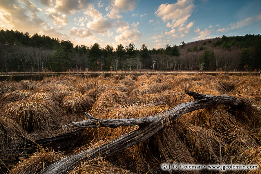
Rifle Range Pond in Mattatuck State Forest, Waterbury, Connecticut

April may have melted the ice from these quiet swamplands amidst the hills north of Connecticut’s Brass City, but the sedges and woodlands alike still bide their time, laying dormant until springtime manages to relax the harshness of New England’s elements.

For me, it’s always illuminating to gain a historical perspective of my subject matter; it can even go a long way towards deepening my creative efforts. But the ease with which I’m able to delve into the past varies sharply from one place to the next and, on occasion, I’m a bit surprised to find how little has been written about certain places in Connecticut despite this state’s nearly 400 years of recorded history.

One such case is Rifle Range Pond, a roughly 14-acre expanse of water and wetlands in Mattatuck State Forest which is just barely contained by Waterbury’s northern border. With such a distinctive name, you’d think it shouldn’t be too hard to uncover some sort of insight into it’s past. And yet, I’ve come up empty-handed on this one. The pond doesn’t appear on USGS topographic maps until 1951 and doesn’t even appear with the name “Rifle Range Pond” until 1968. But given its relatively secluded location along Spruce Brook Road, which is devoid of any nearby shooting ranges as far as I can tell, this pond’s backstory remains a mystery for the time being.

Purchase a Fine Art Print or Inquire About Licensing

Click here to visit my landing page for “Spring of the Sedges” to buy a beautiful fine art print or inquire about licensing this image.

Want to See More?

Be sure to check out more of my work from Waterbury, Connecticut.

Categories
All Things Connecticut New Print Releases The American Northeast

When Railroads Were King

Jericho Crossing at Thomaston (Jericho Bridge over the Naugatuck River, Thomaston, Connecticut)

The Jericho Bridge, its weathered girder frame showing all 112 years of its age, spans the shadow-laden waters of the Naugatuck River amidst the wooded hills in Thomaston. Although it’s January in the valley and shelf ice is forming along the river banks, the molten light of dawn imparts the comforting illusion of warmth.

It’s difficult to overstate how big railroads used to be in Connecticut: not just in terms of their sprawl throughout the state, which was impressive, but in terms of the degree to which they dominated transportation. When the Jericho Bridge was built in 1907 to carry a line of the New York, New Haven & Hartford Railroad over the Naugatuck, it was just one, tiny facet of an immense railroad monopoly that would’ve seemed virtually infinite in its influence and power.

And yet, before Jericho Bridge had even a spot of rust, things were to begin slowly changing for the once-untouchable railroad giant. In time, the rise of automobiles and the subsequent development of highways changed the way we traveled, changed the way we transported goods and changed our society, in general. The Golden Age of the Railroad was arguably over by the 1920s and 1930s… though the industry struggled forth even as its eventual demise grew ever more imminent. All the Northeastern railroad titans just slowly fizzled away over decades of steady decline; most were ghosts of their former selves by the 1960s and 1970s, if they hadn’t thrown in the towel altogether. Remarkably, the Jericho Bridge and the Naugatuck line is still active to this day, though I can’t think of a time I’ve ever seen a single car on its tracks.

Purchase a Fine Art Print or Inquire About Licensing

Click here to visit my landing page for “Jericho Crossing at Thomaston” to buy a beautiful fine art print or inquire about licensing this image.

Want to See More?

Be sure to check out more of my work from Thomaston, Connecticut.

Categories
All Things Connecticut New Print Releases The American Northeast

A Millstone and Main’s Saw

Millstone and Main's Saw (Ledyard Up-down Sawmill, Sawmill Park, Ledyard, Connecticut)
“Millstone and Main’s Saw”
Ledyard Up-down Sawmill at Sawmill Park, Ledyard, Connecticut
© 2016 J. G. Coleman

Dark woodlands, growing ever more leaf-bare as October wanes, rise up behind an old, weather-beaten sawmill in southeastern Connecticut. Nearby, the keyed eye and carefully chiseled grooves of an ancient millstone serve to further recall the days when small, industrious, stream-side mills churned away at the heart of New England’s villages.

Perched beside the sluiceway of a two-acre millpond in the heart of Ledyard, the old Main Sawmill remarkably changed hands only twice since it was constructed in the 19th century. Built by the Brown family in 1877, it proved to be something of a financial failure and was transferred by foreclosure to the Main family in 1902. The Mains operated the mill occasionally until it was damaged by the Great Hurricane of 1938. By the 1960s, in recognition of its historical value, the antique sawmill was purchased by the town of Ledyard to be restored and preserved.

The mill saws logs by lifting and dropping a long, toothed blade along the cut axis, a system known colloquially as an “up-down” saw. Interestingly, the “up-down” design was considered outdated even when the mill was originally built in the 1870s! Why the Brown family neglected to build their mill with a more modern circular saw is anybody’s guess. In retrospect, though, that questionable decision has paid dividends by offering today’s generation a glimpse into sawmill technology that dates back even further than the mill itself!

Purchase a Fine Art Print or Inquire About Licensing

Click here to visit my landing page for “Millstone and Main’s Saw” to buy a beautiful fine art print or inquire about licensing this image.

Want to See More?

Be sure to check out all of my work from the Ledyard Up-down Sawmill and Sawmill Park.

Categories
All Things Connecticut New Print Releases The American Northeast

Waterville Echoes

Sheffield Revenant (Old Sheffield Street Iron Bridge, Mattatuck State Forest, Waterbury, Connecticut, USA)
“Sheffield Revenant”
Old Sheffield Street Iron Bridge,
Mattatuck State Forest, Waterbury, Connecticut
© 2016 J. G. Coleman

The year was 1884. The Waterville manufacturing district in the north of Waterbury had grown to be quite the industrial powerhouse, churning out a seemingly endless supply of brass and cutlery. But Hancock Brook, a tributary of the Naugatuck River which coursed through a steep ravine along Sheffield Street, was a routine impediment to the transport of goods eastward.

Iron Relic of Waterville (Old Sheffield Street Iron Bridge, Mattatuck State Forest, Waterbury, Connecticut)
“Iron Relic of Waterville”
Old Sheffield Street Iron Bridge,
Mattatuck State Forest, Waterbury, Connecticut
© 2016 J. G. Coleman

In an era when wooden covered bridges were still being phased out of mainstream construction in New England, the famous Berlin Iron Bridge Company was contracted to build a hefty iron bridge over Hancock Brook that would accommodate two lanes and exceptionally heavy loads. For years afterward, as countless tons of product fresh from the Waterville factories began their journey to distant destinations, they first cleared Hancock Brook over the Sheffield Street Bridge.

But that was then; this is now. As Waterbury’s golden age of manufacturing declined, the industrial landscape it occupied atrophied and eventually grew wilder than it had been in over a century. Today, the forgotten bridge off Sheffield rusts away in the forest near an isolated quarry. Much of the old wooden decking has long-since decayed, though stray planks sometimes still break free and plunge into the waters below. All that remains of the Sheffield Street Bridge is a haunting, iron skeleton hung high above Hancock Brook… an eerie, lonesome witness of bygone times marooned in a vastly different world from the one in which it was born.

Purchase a Fine Art Print or Inquire About Licensing

Click here to visit my landing page for “Sheffield Revenant” to buy a beautiful fine art print or inquire about licensing this image.

Want to See More?

Be sure to check out all of my work from Mattatuck State Forest.

Categories
All Things Connecticut New Print Releases The American Northeast

Remembering Pastoral Colebrook

Yankee Farmlands № 48 (Old Hale Farm, Colebrook, Connecticut)
“Yankee Farmlands № 48”
Old Hale Farm, Colebrook, Connecticut
© 2016 J. G. Coleman

When author John Barber wrote of Colebrook in the 1830s, he described the land as “hilly and mountainous”, the soil as “generally stony” and the climate as “rather cold and wet”. It would be difficult to paint a bleaker picture of this village in Connecticut’s Northwest Hills. As if he felt obligated to offer at least one redeeming quality, Barber conceded that it “affords tolerable… grazing.”

In truth, Colebrook proved to be a productive area of the state for dairy farming, even if agriculture mostly vanished from its hills over the last century. Unlike many of Connecticut’s towns, which became densely populated with suburbs after farming declined, Colebrook’s abandoned pastures and hayfields were largely covered over by expansive forests. Today, less than 1,500 people make their home among its 30 square miles of remote woodlands. This barn, built in the late 1700s, and the surrounding pastureland is preserved by a local land trust and stands as something of a memorial to generations of hard-scrabble farmers that settled Colebrook long ago.

Purchase a Fine Art Print or Inquire About Licensing

Click here to visit my landing page for “Yankee Farmlands № 48” to buy a beautiful fine art print or inquire about licensing this image.

Want to See More?

Be sure to check out all of the work from my on-going Yankee Farmlands project, a journey throughout Connecticut’s farms in celebration of New England’s agricultural heritage.